Wangmo geodata
Wangmo (Gansu) is a seat of a fourth-order administrative division; located in China in Asia/Shanghai (GMT+8) time zone. In our database, there are 1268 cities with bigger population. Compared to other cities in China, 69.5% of cities are located further ↓South; 87.9% of cities are located further →East and 86.3% of cities have lower elevation than Wangmo. Note1


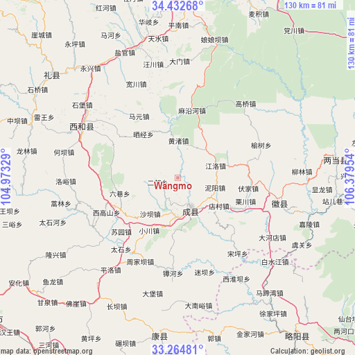
Wangmo GPS coordinates[2]
33° 51' 2.664" North, 105° 40' 35.076" East
| Map corner | latitude | longitude |
|---|---|---|
| Upper-left | 34.43268°, | 104.97329° |
| Center: | 33.85074°, | 105.67641° |
| Lower-right: | 33.26481°, | 106.37954° |
| Map W x H: | 129.9×129.9 km | = 80.7×80.7mi |
| max Lat: | 53.31946° ⇑30.5% North |
| Wangmo: | 33.85074° |
| min Lat: | ⇓69.5% South 18.22056° |
| min Long | Wangmo | max Long |
| 75.07348° | 105.67641° | 134.28917° |
| W 12.1%⇐ | ⇒87.9% E |
Elevation
Elevation of Wangmo is 1063 m = 3488 ft, and this is 578.2 m = 1897 ft above average elevation for this country.
| Max E: |
5622 m = 18445 ft | 13.7% |
| Wangmo | 1063 m 3488 ft | |
| Avg. | 484.8 m = 1591 ft | |
Min E: |
-3 m = -10 ft | 86.3% |
See also: China elevation on elevation.city.
Geographical zone
Wangmo is located in North temperate zone (between Tropic of Cancer and the Arctic Circle). Distance of this Northern Tropic circle is 1157.9 km =719.5 mi to South.| Distance of | km | miles | from Wangmo |
|---|---|---|---|
| North Pole | 6243.2 | 3879.3 | to North |
| Arctic Circle | 3637.3 | 2260.1 | to North |
| Tropic Cancer | 1157.9 | 719.5 | to South |
| Equator | 3763.8 | 2338.7 | to South |


Nearby cities:
15 places around Wangmo: (largest is in red/bold)
• Chengxian Chengguanzhen
12.6 km =7.8 mi,  155°
155°
• Chenyuan
9.6 km =6 mi,  180°
180°
• Diancun
15.8 km =9.8 mi,  124°
124°
• Erlang
8.2 km =5.1 mi,  261°
261°
• Huangzhu
13 km =8.1 mi,  2°
2°
• Huaya
21.6 km =13.4 mi,  185°
185°
• Jiangluo
14.6 km =9.1 mi,  67°
67°
• Liuxiang
22.2 km =13.8 mi, 255°
• Niyang
13.8 km =8.6 mi,  104°
104°
• Paosha
14.1 km =8.8 mi, 180°
• Shaba
16.9 km =10.5 mi,  217°
217°
• Shuiquan
6.1 km =3.8 mi,  135°
135°
• Xiaochuan
21.7 km =13.5 mi,  209°
209°
• Youlongchuan
19.4 km =12.1 mi,  77°
77°
• Zhiqi
12.9 km =8 mi,  151°
151°
Sources, notices
• [Note1] Compared only with cities in China existing in our database
• [Src1] Map data: © OpenStreetMap contributors (CC-BY-SA)
• [Src2] Other city data from geonames.org with taken over terms of usage.
• [Src3] Geographical zone / Annual Mean Temperature by Robert A. Rohde @ Wikipedia
