Fuyong geodata
Fuyong (Guangdong) is a seat of a fourth-order administrative division; located in China in Asia/Shanghai (GMT+8) time zone. In our database, there are 1268 cities with bigger population. Compared to other cities in China, 95.8% of cities are located further ↑North; 52.5% of cities are located further →East and 91.2% of cities have higher elevation than Fuyong. Note1


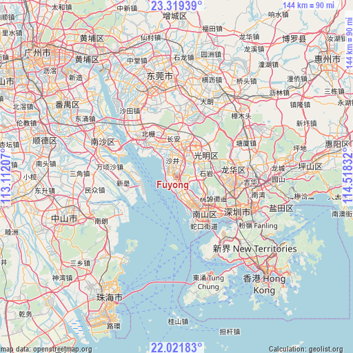
Fuyong GPS coordinates[2]
22° 40' 19.704" North, 113° 48' 54.684" East
| Map corner | latitude | longitude |
|---|---|---|
| Upper-left | 23.31939°, | 113.11207° |
| Center: | 22.67214°, | 113.81519° |
| Lower-right: | 22.02183°, | 114.51832° |
| Map W x H: | 144.3×144.3 km | = 89.7×89.7mi |
| max Lat: | 53.31946° ⇑95.8% North |
| Fuyong: | 22.67214° |
| min Lat: | ⇓4.2% South 18.22056° |
| min Long | Fuyong | max Long |
| 75.07348° | 113.81519° | 134.28917° |
| W 47.5%⇐ | ⇒52.5% E |
Elevation
Elevation of Fuyong is 9 m = 30 ft, and this is 475.8 m = 1561 ft below average elevation for this country.
| Max E: |
5622 m = 18445 ft | 91.2% |
| Avg. | 484.8 m = 1591 ft | |
| Fuyong | 9 m = 30 ft | |
Min E: |
-3 m = -10 ft | 8.8% |
See also: China elevation on elevation.city.
Geographical zone
Fuyong is located in North Torrid zone (between Equator and Tropic of Cancer). Distance of this Northern Tropic circle is 85 km =52.8 mi to North.| Distance of | km | miles | from Fuyong |
|---|---|---|---|
| North Pole | 7486.2 | 4651.7 | to North |
| Arctic Circle | 4880.3 | 3032.5 | to North |
| Tropic Cancer | 85 | 52.8 | to North |
| Equator | 2520.9 | 1566.4 | to South |


Nearby cities:
15 places around Fuyong: (largest is in red/bold)
• Chang’an
15 km =9.3 mi,  355°
355°
• Dalang
19.9 km =12.4 mi,  88°
88°
• Gongming
14.6 km =9.1 mi,  28°
28°
• Guangming
16.2 km =10.1 mi,  46°
46°
• Longhua
19.9 km =12.4 mi, 94°
• Nanshan
19.6 km =12.2 mi,  139°
139°
• Nantou
18.4 km =11.4 mi,  145°
145°
• Shajing
8.3 km =5.2 mi,  2°
2°
• Shiyan
13 km =8.1 mi,  83°
83°
• Songgang
12.2 km =7.6 mi,  14°
14°
• Taoyuan
18.1 km =11.2 mi,  124°
124°
• Xili
16.5 km =10.3 mi, 124°
• Xinwan
19.7 km =12.2 mi,  310°
310°
• Xin’an
15.2 km =9.4 mi, 136°
• Xixiang
11.6 km =7.2 mi, 139°
Sources, notices
• [Note1] Compared only with cities in China existing in our database
• [Src1] Map data: © OpenStreetMap contributors (CC-BY-SA)
• [Src2] Other city data from geonames.org with taken over terms of usage.
• [Src3] Geographical zone / Annual Mean Temperature by Robert A. Rohde @ Wikipedia
