Xinwan geodata
Xinwan (Guangdong) is a seat of a fourth-order administrative division; located in China in Asia/Shanghai (GMT+8) time zone. In our database, there are 1268 cities with bigger population. Compared to other cities in China, 95.3% of cities are located further ↑North; 53.2% of cities are located further →East and 97.2% of cities have higher elevation than Xinwan. Note1


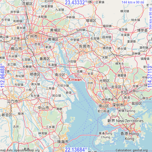
Xinwan GPS coordinates[2]
22° 47' 11.832" North, 113° 40' 4.8" East
| Map corner | latitude | longitude |
|---|---|---|
| Upper-left | 23.43332°, | 112.96488° |
| Center: | 22.78662°, | 113.668° |
| Lower-right: | 22.13684°, | 114.37113° |
| Map W x H: | 144.2×144.2 km | = 89.6×89.6mi |
| max Lat: | 53.31946° ⇑95.3% North |
| Xinwan: | 22.78662° |
| min Lat: | ⇓4.7% South 18.22056° |
| min Long | Xinwan | max Long |
| 75.07348° | 113.668° | 134.28917° |
| W 46.8%⇐ | ⇒53.2% E |
Elevation
Elevation of Xinwan is 5 m = 16 ft, and this is 479.8 m = 1574 ft below average elevation for this country.
| Max E: |
5622 m = 18445 ft | 97.2% |
| Avg. | 484.8 m = 1591 ft | |
| Xinwan | 5 m = 16 ft | |
Min E: |
-3 m = -10 ft | 2.8% |
See also: China elevation on elevation.city.
Geographical zone
Xinwan is located in North Torrid zone (between Equator and Tropic of Cancer). Distance of this Northern Tropic circle is 72.3 km =44.9 mi to North.| Distance of | km | miles | from Xinwan |
|---|---|---|---|
| North Pole | 7473.4 | 4643.8 | to North |
| Arctic Circle | 4867.5 | 3024.5 | to North |
| Tropic Cancer | 72.3 | 44.9 | to North |
| Equator | 2533.6 | 1574.3 | to South |


Nearby cities:
15 places around Xinwan: (largest is in red/bold)
• Chang’an
14 km =8.7 mi,  80°
80°
• Daojiao
23.9 km =14.9 mi,  357°
357°
• Dongyong
24.4 km =15.2 mi,  297°
297°
• Fuyong
19.7 km =12.2 mi,  130°
130°
• Gongming
22 km =13.7 mi,  89°
89°
• Hengli
19.8 km =12.3 mi,  252°
252°
• Hongmei
24 km =14.9 mi,  344°
344°
• Houjie
17.6 km =10.9 mi, 355°
• Huangge
17.2 km =10.7 mi,  285°
285°
• Humen
3.6 km =2.2 mi,  8°
8°
• Nansha
10.4 km =6.5 mi,  280°
280°
• Shajing
16.1 km =10 mi,  106°
106°
• Shatian
16.3 km =10.1 mi, 339°
• Songgang
18.2 km =11.3 mi, 92°
• Wanqingsha
15.5 km =9.6 mi,  234°
234°
Sources, notices
• [Note1] Compared only with cities in China existing in our database
• [Src1] Map data: © OpenStreetMap contributors (CC-BY-SA)
• [Src2] Other city data from geonames.org with taken over terms of usage.
• [Src3] Geographical zone / Annual Mean Temperature by Robert A. Rohde @ Wikipedia
