Songgang geodata
Songgang (Guangdong) is a seat of a fourth-order administrative division; located in China in Asia/Shanghai (GMT+8) time zone. In our database, there are 1268 cities with bigger population. Compared to other cities in China, 95.4% of cities are located further ↑North; 52.3% of cities are located further →East and 86.2% of cities have higher elevation than Songgang. Note1


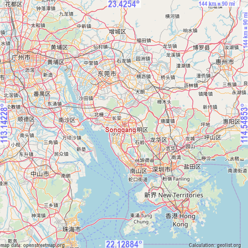
Songgang GPS coordinates[2]
22° 46' 43.176" North, 113° 50' 43.44" East
| Map corner | latitude | longitude |
|---|---|---|
| Upper-left | 23.4254°, | 113.14228° |
| Center: | 22.77866°, | 113.8454° |
| Lower-right: | 22.12884°, | 114.54853° |
| Map W x H: | 144.2×144.2 km | = 89.6×89.6mi |
| max Lat: | 53.31946° ⇑95.4% North |
| Songgang: | 22.77866° |
| min Lat: | ⇓4.6% South 18.22056° |
| min Long | Songgang | max Long |
| 75.07348° | 113.8454° | 134.28917° |
| W 47.7%⇐ | ⇒52.3% E |
Elevation
Elevation of Songgang is 14 m = 46 ft, and this is 470.8 m = 1545 ft below average elevation for this country.
| Max E: |
5622 m = 18445 ft | 86.2% |
| Avg. | 484.8 m = 1591 ft | |
| Songgang | 14 m = 46 ft | |
Min E: |
-3 m = -10 ft | 13.8% |
See also: China elevation on elevation.city.
Geographical zone
Songgang is located in North Torrid zone (between Equator and Tropic of Cancer). Distance of this Northern Tropic circle is 73.2 km =45.5 mi to North.| Distance of | km | miles | from Songgang |
|---|---|---|---|
| North Pole | 7474.3 | 4644.3 | to North |
| Arctic Circle | 4868.4 | 3025.1 | to North |
| Tropic Cancer | 73.2 | 45.5 | to North |
| Equator | 2532.7 | 1573.7 | to South |


Nearby cities:
15 places around Songgang: (largest is in red/bold)
• Chang’an
5.4 km =3.4 mi,  305°
305°
• Dalang
20.2 km =12.6 mi,  123°
123°
• Dalang
20.6 km =12.8 mi,  24°
24°
• Fuyong
12.2 km =7.6 mi,  194°
194°
• Gongming
3.9 km =2.4 mi,  75°
75°
• Guangming
8.7 km =5.4 mi,  94°
94°
• Guanlan
22.2 km =13.8 mi,  106°
106°
• Huangjiang
22.1 km =13.7 mi,  44°
44°
• Humen
18.2 km =11.3 mi,  284°
284°
• Longhua
21.5 km =13.4 mi,  128°
128°
• Shajing
4.5 km =2.8 mi,  216°
216°
• Shiyan
14.2 km =8.8 mi,  136°
136°
• Xili
23.7 km =14.7 mi,  153°
153°
• Xinwan
18.2 km =11.3 mi,  272°
272°
• Xixiang
21.1 km =13.1 mi,  167°
167°
Sources, notices
• [Note1] Compared only with cities in China existing in our database
• [Src1] Map data: © OpenStreetMap contributors (CC-BY-SA)
• [Src2] Other city data from geonames.org with taken over terms of usage.
• [Src3] Geographical zone / Annual Mean Temperature by Robert A. Rohde @ Wikipedia
