Fuyang geodata
Fuyang (Guizhou) is a seat of a fourth-order administrative division; located in China in Asia/Shanghai (GMT+8) time zone. In our database, there are 1268 cities with bigger population. Compared to other cities in China, 69.4% of cities are located further ↑North; 81.4% of cities are located further →East and 78.8% of cities have lower elevation than Fuyang. Note1


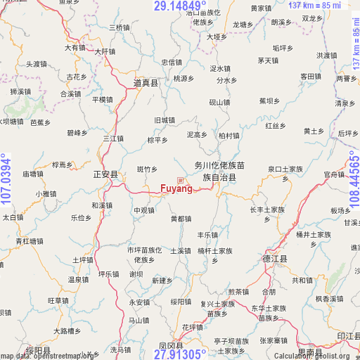
Fuyang GPS coordinates[2]
28° 31' 57.288" North, 107° 44' 33.072" East
| Map corner | latitude | longitude |
|---|---|---|
| Upper-left | 29.14849°, | 107.0394° |
| Center: | 28.53258°, | 107.74252° |
| Lower-right: | 27.91305°, | 108.44565° |
| Map W x H: | 137.4×137.4 km | = 85.4×85.4mi |
| max Lat: | 53.31946° ⇑69.4% North |
| Fuyang: | 28.53258° |
| min Lat: | ⇓30.6% South 18.22056° |
| min Long | Fuyang | max Long |
| 75.07348° | 107.74252° | 134.28917° |
| W 18.6%⇐ | ⇒81.4% E |
Elevation
Elevation of Fuyang is 645 m = 2116 ft, and this is 160.2 m = 526 ft above average elevation for this country.
| Max E: |
5622 m = 18445 ft | 21.2% |
| Fuyang | 645 m 2116 ft | |
| Avg. | 484.8 m = 1591 ft | |
Min E: |
-3 m = -10 ft | 78.8% |
See also: China elevation on elevation.city.
Geographical zone
Fuyang is located in North temperate zone (between Tropic of Cancer and the Arctic Circle). Distance of this Northern Tropic circle is 566.6 km =352.1 mi to South.| Distance of | km | miles | from Fuyang |
|---|---|---|---|
| North Pole | 6834.5 | 4246.8 | to North |
| Arctic Circle | 4228.6 | 2627.5 | to North |
| Tropic Cancer | 566.6 | 352.1 | to South |
| Equator | 3172.5 | 1971.3 | to South |


Nearby cities:
15 places around Fuyang: (largest is in red/bold)
• Baicun
25.3 km =15.7 mi,  46°
46°
• Banzhu
13.7 km =8.5 mi,  290°
290°
• Daping
19.5 km =12.1 mi,  73°
73°
• Duru
14.1 km =8.8 mi,  93°
93°
• Fengle
23 km =14.3 mi,  151°
151°
• Gelin
22 km =13.7 mi,  274°
274°
• Huangdu
14.4 km =8.9 mi,  179°
179°
• Jianping
24.7 km =15.3 mi, 266°
• Jiucheng
24 km =14.9 mi,  345°
345°
• Longxing
24.9 km =15.5 mi,  309°
309°
• Nigao
18.8 km =11.7 mi,  19°
19°
• Tuxi
26.1 km =16.2 mi, 178°
• Zhennan
22.6 km =14 mi,  33°
33°
• Zhongguan
17.8 km =11.1 mi,  230°
230°
• Zongping
17.9 km =11.1 mi,  330°
330°
Sources, notices
• [Note1] Compared only with cities in China existing in our database
• [Src1] Map data: © OpenStreetMap contributors (CC-BY-SA)
• [Src2] Other city data from geonames.org with taken over terms of usage.
• [Src3] Geographical zone / Annual Mean Temperature by Robert A. Rohde @ Wikipedia
