Baicun geodata
Baicun (Guizhou) is a seat of a fourth-order administrative division; located in China in Asia/Shanghai (GMT+8) time zone. In our database, there are 1268 cities with bigger population. Compared to other cities in China, 68% of cities are located further ↑North; 80.8% of cities are located further →East and 78.5% of cities have lower elevation than Baicun. Note1


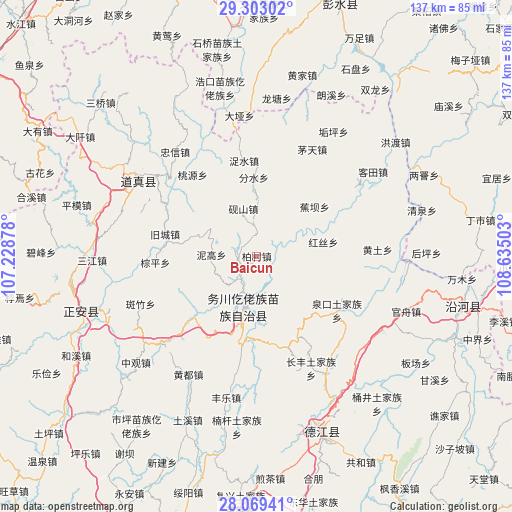
Baicun GPS coordinates[2]
28° 41' 16.908" North, 107° 55' 54.84" East
| Map corner | latitude | longitude |
|---|---|---|
| Upper-left | 29.30302°, | 107.22878° |
| Center: | 28.68803°, | 107.9319° |
| Lower-right: | 28.06941°, | 108.63503° |
| Map W x H: | 137.2×137.2 km | = 85.3×85.3mi |
| max Lat: | 53.31946° ⇑68% North |
| Baicun: | 28.68803° |
| min Lat: | ⇓32% South 18.22056° |
| min Long | Baicun | max Long |
| 75.07348° | 107.9319° | 134.28917° |
| W 19.2%⇐ | ⇒80.8% E |
Elevation
Elevation of Baicun is 634 m = 2080 ft, and this is 149.2 m = 490 ft above average elevation for this country.
| Max E: |
5622 m = 18445 ft | 21.5% |
| Baicun | 634 m 2080 ft | |
| Avg. | 484.8 m = 1591 ft | |
Min E: |
-3 m = -10 ft | 78.5% |
See also: China elevation on elevation.city.
Geographical zone
Baicun is located in North temperate zone (between Tropic of Cancer and the Arctic Circle). Distance of this Northern Tropic circle is 583.9 km =362.8 mi to South.| Distance of | km | miles | from Baicun |
|---|---|---|---|
| North Pole | 6817.3 | 4236.1 | to North |
| Arctic Circle | 4211.4 | 2616.8 | to North |
| Tropic Cancer | 583.9 | 362.8 | to South |
| Equator | 3189.8 | 1982 | to South |


Nearby cities:
15 places around Baicun: (largest is in red/bold)
• Daping
11.7 km =7.3 mi,  178°
178°
• Duru
18.6 km =11.6 mi,  193°
193°
• Fenshui
21.7 km =13.5 mi,  5°
5°
• Fuyang
25.3 km =15.7 mi,  226°
226°
• Hongsi
18.2 km =11.3 mi,  77°
77°
• Jiaoba
20.4 km =12.7 mi,  49°
49°
• Jiucheng
25.2 km =15.7 mi,  283°
283°
• Nigao
12.1 km =7.5 mi,  271°
271°
• Quankou
25.1 km =15.6 mi,  127°
127°
• Taoyuan
27.7 km =17.2 mi,  321°
321°
• Yanshan
13.2 km =8.2 mi,  344°
344°
• Zhennan
6.1 km =3.8 mi, 284°
• Zhongzhai
25.7 km =16 mi,  117°
117°
• Zhuoshui
25.8 km =16 mi,  352°
352°
• Zongping
27.2 km =16.9 mi, 266°
Sources, notices
• [Note1] Compared only with cities in China existing in our database
• [Src1] Map data: © OpenStreetMap contributors (CC-BY-SA)
• [Src2] Other city data from geonames.org with taken over terms of usage.
• [Src3] Geographical zone / Annual Mean Temperature by Robert A. Rohde @ Wikipedia
