Futian geodata
Futian (Jiangxi) is a seat of a fourth-order administrative division; located in China in Asia/Shanghai (GMT+8) time zone. In our database, there are 1268 cities with bigger population. Compared to other cities in China, 79.3% of cities are located further ↑North; 55.6% of cities are located further ←West and 57.9% of cities have higher elevation than Futian. Note1


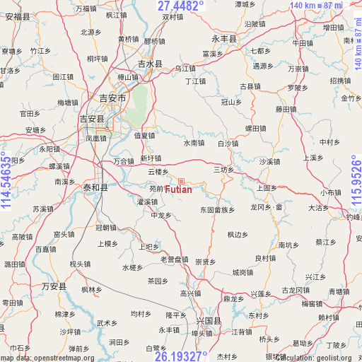
Futian GPS coordinates[2]
26° 49' 20.892" North, 115° 14' 58.092" East
| Map corner | latitude | longitude |
|---|---|---|
| Upper-left | 27.4482°, | 114.54635° |
| Center: | 26.82247°, | 115.24947° |
| Lower-right: | 26.19327°, | 115.9526° |
| Map W x H: | 139.5×139.5 km | = 86.7×86.7mi |
| max Lat: | 53.31946° ⇑79.3% North |
| Futian: | 26.82247° |
| min Lat: | ⇓20.7% South 18.22056° |
| min Long | Futian | max Long |
| 75.07348° | 115.24947° | 134.28917° |
| W 55.6%⇐ | ⇒44.4% E |
Elevation
Elevation of Futian is 112 m = 367 ft, and this is 372.8 m = 1223 ft below average elevation for this country.
| Max E: |
5622 m = 18445 ft | 57.9% |
| Avg. | 484.8 m = 1591 ft | |
| Futian | 112 m = 367 ft | |
Min E: |
-3 m = -10 ft | 42.1% |
See also: China elevation on elevation.city.
Geographical zone
Futian is located in North temperate zone (between Tropic of Cancer and the Arctic Circle). Distance of this Northern Tropic circle is 376.5 km =233.9 mi to South.| Distance of | km | miles | from Futian |
|---|---|---|---|
| North Pole | 7024.7 | 4364.9 | to North |
| Arctic Circle | 4418.8 | 2745.7 | to North |
| Tropic Cancer | 376.5 | 233.9 | to South |
| Equator | 2982.4 | 1853.2 | to South |


Nearby cities:
15 places around Futian: (largest is in red/bold)
• Baisha
23.6 km =14.7 mi,  51°
51°
• Donggu
17.7 km =11 mi,  127°
127°
• Futan
21.2 km =13.2 mi,  332°
332°
• Guanxi
14.8 km =9.2 mi,  238°
238°
• Sanfang
17.2 km =10.7 mi,  72°
72°
• Shangyi
27.9 km =17.3 mi,  206°
206°
• Shuinan
15.9 km =9.9 mi,  18°
18°
• Tantou
23.9 km =14.9 mi,  86°
86°
• Wanhe
23.5 km =14.6 mi,  290°
290°
• Wenbei
18.9 km =11.7 mi,  314°
314°
• Xiaolong
15.6 km =9.7 mi,  178°
178°
• Xinxu
14.7 km =9.1 mi, 309°
• Yuanqian
8.5 km =5.3 mi,  253°
253°
• Zhixia
22.4 km =13.9 mi,  322°
322°
• Zhonglong
15.1 km =9.4 mi, 211°
Sources, notices
• [Note1] Compared only with cities in China existing in our database
• [Src1] Map data: © OpenStreetMap contributors (CC-BY-SA)
• [Src2] Other city data from geonames.org with taken over terms of usage.
• [Src3] Geographical zone / Annual Mean Temperature by Robert A. Rohde @ Wikipedia
