Fufeng geodata
Fufeng (Shaanxi) is a seat of a third-order administrative division; located in China in Asia/Shanghai (GMT+8) time zone. In our database, there are 1268 cities with bigger population. Compared to other cities in China, 71.9% of cities are located further ↓South; 81% of cities are located further →East and 75.4% of cities have lower elevation than Fufeng. Note1


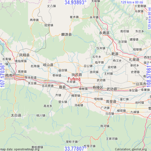
Fufeng GPS coordinates[2]
34° 21' 37.836" North, 107° 52' 24.528" East
| Map corner | latitude | longitude |
|---|---|---|
| Upper-left | 34.93893°, | 107.17036° |
| Center: | 34.36051°, | 107.87348° |
| Lower-right: | 33.77807°, | 108.57661° |
| Map W x H: | 129.1×129.1 km | = 80.2×80.2mi |
| max Lat: | 53.31946° ⇑28.1% North |
| Fufeng: | 34.36051° |
| min Lat: | ⇓71.9% South 18.22056° |
| min Long | Fufeng | max Long |
| 75.07348° | 107.87348° | 134.28917° |
| W 19%⇐ | ⇒81% E |
Elevation
Elevation of Fufeng is 531 m = 1742 ft, and this is 46.2 m = 152 ft above average elevation for this country.
| Max E: |
5622 m = 18445 ft | 24.6% |
| Fufeng | 531 m 1742 ft | |
| Avg. | 484.8 m = 1591 ft | |
Min E: |
-3 m = -10 ft | 75.4% |
See also: China elevation on elevation.city.
Geographical zone
Fufeng is located in North temperate zone (between Tropic of Cancer and the Arctic Circle). Distance of this Northern Tropic circle is 1214.6 km =754.7 mi to South.| Distance of | km | miles | from Fufeng |
|---|---|---|---|
| North Pole | 6186.5 | 3844.1 | to North |
| Arctic Circle | 3580.6 | 2224.9 | to North |
| Tropic Cancer | 1214.6 | 754.7 | to South |
| Equator | 3820.5 | 2373.9 | to South |


Nearby cities:
15 places around Fufeng: (largest is in red/bold)
• Changxing
10.6 km =6.6 mi,  199°
199°
• Duanjia
6.4 km =4 mi,  151°
151°
• Famen
8.8 km =5.5 mi,  15°
15°
• Jiangzhang
12.1 km =7.5 mi,  158°
158°
• Nanyang
15.1 km =9.4 mi, 20°
• Qinghua
8 km =5 mi,  334°
334°
• Shangsong
10.6 km =6.6 mi,  178°
178°
• Shoushan
14.9 km =9.3 mi,  231°
231°
• Taibai
8.2 km =5.1 mi,  89°
89°
• Wujing
6.6 km =4.1 mi,  221°
221°
• Wuquan
12.9 km =8 mi,  121°
121°
• Xinglin
10.9 km =6.8 mi,  99°
99°
• Yidian
12 km =7.5 mi,  293°
293°
• Zhaogong
13.7 km =8.5 mi,  50°
50°
• Zhujiazhuang
15.1 km =9.4 mi, 325°
Sources, notices
• [Note1] Compared only with cities in China existing in our database
• [Src1] Map data: © OpenStreetMap contributors (CC-BY-SA)
• [Src2] Other city data from geonames.org with taken over terms of usage.
• [Src3] Geographical zone / Annual Mean Temperature by Robert A. Rohde @ Wikipedia
