Wujing geodata
Wujing (Shaanxi) is a seat of a fourth-order administrative division; located in China in Asia/Shanghai (GMT+8) time zone. In our database, there are 1268 cities with bigger population. Compared to other cities in China, 71.6% of cities are located further ↓South; 81.2% of cities are located further →East and 78.8% of cities have lower elevation than Wujing. Note1


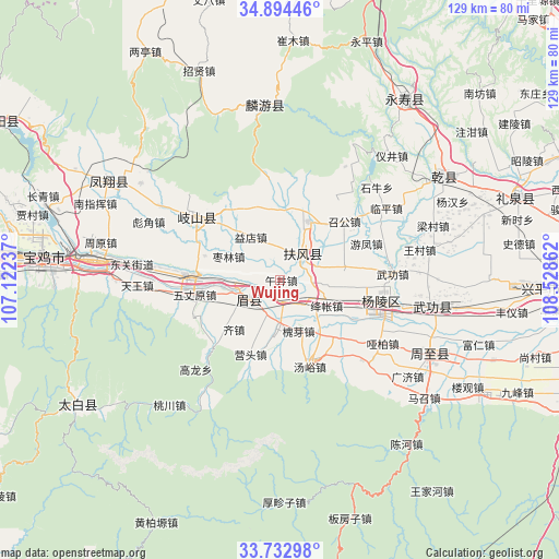
Wujing GPS coordinates[2]
34° 18' 56.628" North, 107° 49' 31.764" East
| Map corner | latitude | longitude |
|---|---|---|
| Upper-left | 34.89446°, | 107.12237° |
| Center: | 34.31573°, | 107.82549° |
| Lower-right: | 33.73298°, | 108.52862° |
| Map W x H: | 129.1×129.1 km | = 80.2×80.2mi |
| max Lat: | 53.31946° ⇑28.4% North |
| Wujing: | 34.31573° |
| min Lat: | ⇓71.6% South 18.22056° |
| min Long | Wujing | max Long |
| 75.07348° | 107.82549° | 134.28917° |
| W 18.8%⇐ | ⇒81.2% E |
Elevation
Elevation of Wujing is 645 m = 2116 ft, and this is 160.2 m = 526 ft above average elevation for this country.
| Max E: |
5622 m = 18445 ft | 21.2% |
| Wujing | 645 m 2116 ft | |
| Avg. | 484.8 m = 1591 ft | |
Min E: |
-3 m = -10 ft | 78.8% |
See also: China elevation on elevation.city.
Geographical zone
Wujing is located in North temperate zone (between Tropic of Cancer and the Arctic Circle). Distance of this Northern Tropic circle is 1209.6 km =751.6 mi to South.| Distance of | km | miles | from Wujing |
|---|---|---|---|
| North Pole | 6191.5 | 3847.2 | to North |
| Arctic Circle | 3585.6 | 2228 | to North |
| Tropic Cancer | 1209.6 | 751.6 | to South |
| Equator | 3815.6 | 2370.9 | to South |


Nearby cities:
15 places around Wujing: (largest is in red/bold)
• Changxing
5.1 km =3.2 mi,  169°
169°
• Duanjia
7.4 km =4.6 mi,  94°
94°
• Famen
15.1 km =9.4 mi,  26°
26°
• Fufeng
6.6 km =4.1 mi,  41°
41°
• Huaiya
12.8 km =8 mi,  160°
160°
• Jiangzhang
10.8 km =6.7 mi,  125°
125°
• Jinqu
12.3 km =7.6 mi,  200°
200°
• Majia
10.9 km =6.8 mi,  266°
266°
• Qinghua
12.3 km =7.6 mi,  4°
4°
• Shangsong
7.3 km =4.5 mi,  140°
140°
• Shoushan
8.4 km =5.2 mi,  239°
239°
• Taibai
13.6 km =8.5 mi,  68°
68°
• Xinglin
15.5 km =9.6 mi,  78°
78°
• Yidian
11.8 km =7.3 mi,  325°
325°
• Zaolin
13 km =8.1 mi,  294°
294°
Sources, notices
• [Note1] Compared only with cities in China existing in our database
• [Src1] Map data: © OpenStreetMap contributors (CC-BY-SA)
• [Src2] Other city data from geonames.org with taken over terms of usage.
• [Src3] Geographical zone / Annual Mean Temperature by Robert A. Rohde @ Wikipedia
