Fu’an geodata
Fu’an (Jiangsu) is a seat of a fourth-order administrative division; located in China in Asia/Shanghai (GMT+8) time zone. In our database, there are 1268 cities with bigger population. Compared to other cities in China, 64.7% of cities are located further ↓South; 84.9% of cities are located further ←West and 94.3% of cities have higher elevation than Fu’an. Note1


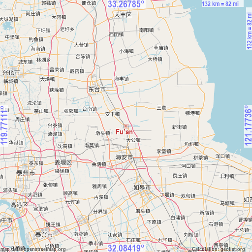
Fu’an GPS coordinates[2]
32° 40' 40.728" North, 120° 28' 27.228" East
| Map corner | latitude | longitude |
|---|---|---|
| Upper-left | 33.26785°, | 119.77111° |
| Center: | 32.67798°, | 120.47423° |
| Lower-right: | 32.08419°, | 121.17736° |
| Map W x H: | 131.6×131.6 km | = 81.8×81.8mi |
| max Lat: | 53.31946° ⇑35.3% North |
| Fu’an: | 32.67798° |
| min Lat: | ⇓64.7% South 18.22056° |
| min Long | Fu’an | max Long |
| 75.07348° | 120.47423° | 134.28917° |
| W 84.9%⇐ | ⇒15.1% E |
Elevation
Elevation of Fu’an is 7 m = 23 ft, and this is 477.8 m = 1568 ft below average elevation for this country.
| Max E: |
5622 m = 18445 ft | 94.3% |
| Avg. | 484.8 m = 1591 ft | |
| Fu’an | 7 m = 23 ft | |
Min E: |
-3 m = -10 ft | 5.7% |
See also: China elevation on elevation.city.
Geographical zone
Fu’an is located in North temperate zone (between Tropic of Cancer and the Arctic Circle). Distance of this Northern Tropic circle is 1027.5 km =638.5 mi to South.| Distance of | km | miles | from Fu’an |
|---|---|---|---|
| North Pole | 6373.6 | 3960.4 | to North |
| Arctic Circle | 3767.7 | 2341.1 | to North |
| Tropic Cancer | 1027.5 | 638.5 | to South |
| Equator | 3633.5 | 2257.8 | to South |


Nearby cities:
15 places around Fu’an: (largest is in red/bold)
• Anfeng
9.4 km =5.8 mi,  310°
310°
• Baidian
20.3 km =12.6 mi,  267°
267°
• Chengdong
16.4 km =10.2 mi,  171°
171°
• Dagong
8.1 km =5 mi,  149°
149°
• Duntou
12.3 km =7.6 mi,  253°
253°
• Fudong
9.1 km =5.7 mi,  59°
59°
• Hai’an
15.1 km =9.4 mi,  188°
188°
• Huji
19.9 km =12.4 mi,  205°
205°
• Liangduo
15 km =9.3 mi,  316°
316°
• Nanshenzao
13 km =8.1 mi,  25°
25°
• Sancang
20.5 km =12.7 mi, 61°
• Sanzao
19.3 km =12 mi, 323°
• Sizao
19.1 km =11.9 mi,  356°
356°
• Xichang
20.3 km =12.6 mi, 147°
• Xuhe
16.5 km =10.3 mi,  70°
70°
Sources, notices
• [Note1] Compared only with cities in China existing in our database
• [Src1] Map data: © OpenStreetMap contributors (CC-BY-SA)
• [Src2] Other city data from geonames.org with taken over terms of usage.
• [Src3] Geographical zone / Annual Mean Temperature by Robert A. Rohde @ Wikipedia
