Fengcheng geodata
Fengcheng (Fujian) is a seat of a third-order administrative division; located in China in Asia/Shanghai (GMT+8) time zone. In our database, there are 1268 cities with bigger population. Compared to other cities in China, 87.5% of cities are located further ↑North; 64.5% of cities are located further ←West and 53.7% of cities have lower elevation than Fengcheng. Note1


Fengcheng GPS coordinates[2]
24° 43' 25.14" North, 116° 43' 27.444" East
| Map corner | latitude | longitude |
|---|---|---|
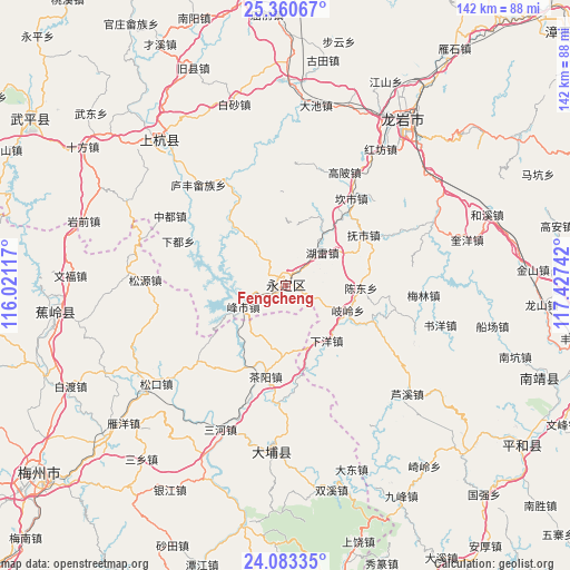
| Upper-left | 25.36067°, | 116.02117° |
| Center: | 24.72365°, | 116.72429° |
| Lower-right: | 24.08335°, | 117.42742° |
| Map W x H: | 142×142 km | = 88.2×88.2mi |
| max Lat: | 53.31946° ⇑87.5% North |
| Fengcheng: | 24.72365° |
| min Lat: | ⇓12.5% South 18.22056° |
| min Long | Fengcheng | max Long |
| 75.07348° | 116.72429° | 134.28917° |
| W 64.5%⇐ | ⇒35.5% E |
Elevation
Elevation of Fengcheng is 195 m = 640 ft, and this is 289.8 m = 951 ft below average elevation for this country.
| Max E: |
5622 m = 18445 ft | 46.3% |
| Avg. | 484.8 m = 1591 ft | |
| Fengcheng | 195 m = 640 ft | |
Min E: |
-3 m = -10 ft | 53.7% |
See also: China elevation on elevation.city.
Geographical zone
Fengcheng is located in North temperate zone (between Tropic of Cancer and the Arctic Circle). Distance of this Northern Tropic circle is 143.1 km =88.9 mi to South.| Distance of | km | miles | from Fengcheng |
|---|---|---|---|
| North Pole | 7258 | 4509.9 | to North |
| Arctic Circle | 4652.2 | 2890.7 | to North |
| Tropic Cancer | 143.1 | 88.9 | to South |
| Equator | 2749 | 1708.1 | to South |


Nearby cities:
15 places around Fengcheng: (largest is in red/bold)
• Chayang
23.2 km =14.4 mi,  191°
191°
• Chendong
18.8 km =11.7 mi,  91°
91°
• Chengjiao
0.5 km =0.3 mi,  266°
266°
• Daxi
21.3 km =13.2 mi,  118°
118°
• Fengshi
11.5 km =7.1 mi,  243°
243°
• Fushi
23.3 km =14.5 mi,  57°
57°
• Hexi
17.4 km =10.8 mi,  359°
359°
• Hongshan
21.2 km =13.2 mi,  276°
276°
• Hulei
12.1 km =7.5 mi,  49°
49°
• Jinsha
4.8 km =3 mi,  304°
304°
• Qiling
17.4 km =10.8 mi,  107°
107°
• Rentian
19.2 km =11.9 mi,  318°
318°
• Tangbao
18.9 km =11.7 mi,  27°
27°
• Xiayang
17.5 km =10.9 mi,  140°
140°
• Xixi
6.4 km =4 mi,  7°
7°
Sources, notices
• [Note1] Compared only with cities in China existing in our database
• [Src1] Map data: © OpenStreetMap contributors (CC-BY-SA)
• [Src2] Other city data from geonames.org with taken over terms of usage.
• [Src3] Geographical zone / Annual Mean Temperature by Robert A. Rohde @ Wikipedia
