Fushi geodata
Fushi (Fujian) is a seat of a fourth-order administrative division; located in China in Asia/Shanghai (GMT+8) time zone. In our database, there are 1268 cities with bigger population. Compared to other cities in China, 87% of cities are located further ↑North; 65.6% of cities are located further ←West and 62.6% of cities have lower elevation than Fushi. Note1


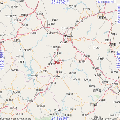
Fushi GPS coordinates[2]
24° 50' 12.372" North, 116° 55' 7.212" East
| Map corner | latitude | longitude |
|---|---|---|
| Upper-left | 25.47321°, | 116.21555° |
| Center: | 24.83677°, | 116.91867° |
| Lower-right: | 24.19704°, | 117.6218° |
| Map W x H: | 141.9×141.9 km | = 88.2×88.2mi |
| max Lat: | 53.31946° ⇑87% North |
| Fushi: | 24.83677° |
| min Lat: | ⇓13% South 18.22056° |
| min Long | Fushi | max Long |
| 75.07348° | 116.91867° | 134.28917° |
| W 65.6%⇐ | ⇒34.4% E |
Elevation
Elevation of Fushi is 291 m = 955 ft, and this is 193.8 m = 636 ft below average elevation for this country.
| Max E: |
5622 m = 18445 ft | 37.4% |
| Avg. | 484.8 m = 1591 ft | |
| Fushi | 291 m = 955 ft | |
Min E: |
-3 m = -10 ft | 62.6% |
See also: China elevation on elevation.city.
Geographical zone
Fushi is located in North temperate zone (between Tropic of Cancer and the Arctic Circle). Distance of this Northern Tropic circle is 155.7 km =96.7 mi to South.| Distance of | km | miles | from Fushi |
|---|---|---|---|
| North Pole | 7245.5 | 4502.1 | to North |
| Arctic Circle | 4639.6 | 2882.9 | to North |
| Tropic Cancer | 155.7 | 96.7 | to South |
| Equator | 2761.6 | 1716 | to South |


Nearby cities:
15 places around Fushi: (largest is in red/bold)
• Chendong
13 km =8.1 mi,  183°
183°
• Daxi
22.9 km =14.2 mi, 182°
• Dongxiao
23.2 km =14.4 mi,  22°
22°
• Gaobei
16.5 km =10.3 mi,  342°
342°
• Guzhu
16.5 km =10.3 mi,  155°
155°
• Hexi
20.2 km =12.6 mi,  283°
283°
• Hugang
21.8 km =13.5 mi,  324°
324°
• Hukeng
21.1 km =13.1 mi,  172°
172°
• Hulei
11.4 km =7.1 mi,  246°
246°
• Kanshi
9.6 km =6 mi, 341°
• Nanyang
21.4 km =13.3 mi,  9°
9°
• Peifeng
8.1 km =5 mi, 15°
• Qiling
18.2 km =11.3 mi,  189°
189°
• Tangbao
11.5 km =7.1 mi,  290°
290°
• Xixi
19.8 km =12.3 mi, 251°
Sources, notices
• [Note1] Compared only with cities in China existing in our database
• [Src1] Map data: © OpenStreetMap contributors (CC-BY-SA)
• [Src2] Other city data from geonames.org with taken over terms of usage.
• [Src3] Geographical zone / Annual Mean Temperature by Robert A. Rohde @ Wikipedia
