Encheng geodata
Encheng (Guangdong) is a seat of a third-order administrative division; located in China in Asia/Shanghai (GMT+8) time zone. With population of 110,921 people, there are 391 cities with bigger population in this country. Compared to other cities in China, 97% of cities are located further ↑North; 61.1% of cities are located further →East and 80.8% of cities have higher elevation than Encheng. Note1


Encheng GPS coordinates[2]
22° 11' 11.724" North, 112° 18' 15.264" East
| Map corner | latitude | longitude |
|---|---|---|
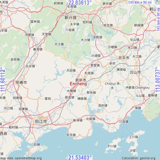
| Upper-left | 22.83613°, | 111.60112° |
| Center: | 22.18659°, | 112.30424° |
| Lower-right: | 21.53403°, | 113.00737° |
| Map W x H: | 144.8×144.8 km | = 90×90mi |
| max Lat: | 53.31946° ⇑97% North |
| Encheng: | 22.18659° |
| min Lat: | ⇓3% South 18.22056° |
| min Long | Encheng | max Long |
| 75.07348° | 112.30424° | 134.28917° |
| W 38.9%⇐ | ⇒61.1% E |
Elevation
Elevation of Encheng is 25 m = 82 ft, and this is 459.8 m = 1509 ft below average elevation for this country.
| Max E: |
5622 m = 18445 ft | 80.8% |
| Avg. | 484.8 m = 1591 ft | |
| Encheng | 25 m = 82 ft | |
Min E: |
-3 m = -10 ft | 19.2% |
See also: Encheng elevation on elevation.city.
Geographical zone
Encheng is located in North Torrid zone (between Equator and Tropic of Cancer). Distance of this Northern Tropic circle is 139 km =86.4 mi to North.| Distance of | km | miles | from Encheng |
|---|---|---|---|
| North Pole | 7540.1 | 4685.2 | to North |
| Arctic Circle | 4934.3 | 3066 | to North |
| Tropic Cancer | 139 | 86.4 | to North |
| Equator | 2466.9 | 1532.9 | to South |


Nearby cities:
15 places around Encheng: (largest is in red/bold)
• Chishui
29.6 km =18.4 mi,  99°
99°
• Dahuai
12.6 km =7.8 mi,  218°
218°
• Datian
11.9 km =7.4 mi,  316°
316°
• Dongcheng
10.3 km =6.4 mi,  50°
50°
• Hengpi
16.6 km =10.3 mi,  175°
175°
• Jinji
18.6 km =11.6 mi, 96°
• Juntang
19.3 km =12 mi,  40°
40°
• Liangxi
15.3 km =9.5 mi,  12°
12°
• Naji
16.6 km =10.3 mi,  244°
244°
• Nalong
19.3 km =12 mi,  210°
210°
• Niujiang
22.5 km =14 mi,  20°
20°
• Pingshi
2.6 km =1.6 mi, 49°
• Shahu
26.6 km =16.5 mi,  31°
31°
• Shengtang
13.9 km =8.6 mi, 33°
• Xiangang
25.9 km =16.1 mi,  65°
65°
Sources, notices
• [Note1] Compared only with cities in China existing in our database
• [Src1] Map data: © OpenStreetMap contributors (CC-BY-SA)
• [Src2] Other city data from geonames.org with taken over terms of usage.
• [Src3] Geographical zone / Annual Mean Temperature by Robert A. Rohde @ Wikipedia
