Dongcheng geodata
Dongcheng (Guangdong) is a seat of a fourth-order administrative division; located in China in Asia/Shanghai (GMT+8) time zone. In our database, there are 1268 cities with bigger population. Compared to other cities in China, 96.9% of cities are located further ↑North; 60.6% of cities are located further →East and 82.9% of cities have higher elevation than Dongcheng. Note1


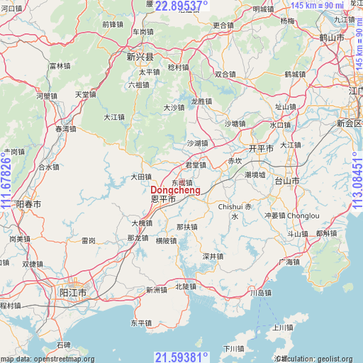
Dongcheng GPS coordinates[2]
22° 14' 45.96" North, 112° 22' 52.968" East
| Map corner | latitude | longitude |
|---|---|---|
| Upper-left | 22.89537°, | 111.67826° |
| Center: | 22.2461°, | 112.38138° |
| Lower-right: | 21.59381°, | 113.08451° |
| Map W x H: | 144.7×144.7 km | = 89.9×89.9mi |
| max Lat: | 53.31946° ⇑96.9% North |
| Dongcheng: | 22.2461° |
| min Lat: | ⇓3.1% South 18.22056° |
| min Long | Dongcheng | max Long |
| 75.07348° | 112.38138° | 134.28917° |
| W 39.4%⇐ | ⇒60.6% E |
Elevation
Elevation of Dongcheng is 20 m = 66 ft, and this is 464.8 m = 1525 ft below average elevation for this country.
| Max E: |
5622 m = 18445 ft | 82.9% |
| Avg. | 484.8 m = 1591 ft | |
| Dongcheng | 20 m = 66 ft | |
Min E: |
-3 m = -10 ft | 17.1% |
See also: China elevation on elevation.city.
Geographical zone
Dongcheng is located in North Torrid zone (between Equator and Tropic of Cancer). Distance of this Northern Tropic circle is 132.4 km =82.3 mi to North.| Distance of | km | miles | from Dongcheng |
|---|---|---|---|
| North Pole | 7533.5 | 4681.1 | to North |
| Arctic Circle | 4927.6 | 3061.9 | to North |
| Tropic Cancer | 132.4 | 82.3 | to North |
| Equator | 2473.5 | 1537 | to South |


Nearby cities:
15 places around Dongcheng: (largest is in red/bold)
• Baisha
21.9 km =13.6 mi,  88°
88°
• Chikan
22.3 km =13.9 mi,  67°
67°
• Chishui
24.2 km =15 mi,  118°
118°
• Dahuai
22.8 km =14.2 mi,  223°
223°
• Datian
16.3 km =10.1 mi,  276°
276°
• Encheng
10.3 km =6.4 mi,  230°
230°
• Hengpi
24 km =14.9 mi,  195°
195°
• Jinji
13.7 km =8.5 mi,  130°
130°
• Juntang
9.3 km =5.8 mi,  28°
28°
• Liangxi
9.5 km =5.9 mi,  331°
331°
• Niujiang
14.5 km =9 mi,  359°
359°
• Pingshi
7.7 km =4.8 mi, 230°
• Shahu
17.1 km =10.6 mi,  20°
20°
• Shengtang
4.9 km =3 mi, 356°
• Xiangang
16.2 km =10.1 mi, 74°
Sources, notices
• [Note1] Compared only with cities in China existing in our database
• [Src1] Map data: © OpenStreetMap contributors (CC-BY-SA)
• [Src2] Other city data from geonames.org with taken over terms of usage.
• [Src3] Geographical zone / Annual Mean Temperature by Robert A. Rohde @ Wikipedia
