Fengshan geodata
Fengshan (Fujian) is a seat of a fourth-order administrative division; located in China in Asia/Shanghai (GMT+8) time zone. In our database, there are 1268 cities with bigger population. Compared to other cities in China, 84% of cities are located further ↑North; 73.6% of cities are located further ←West and 84.6% of cities have lower elevation than Fengshan. Note1


Fengshan GPS coordinates[2]
25° 34' 32.52" North, 118° 33' 24.408" East
| Map corner | latitude | longitude |
|---|---|---|
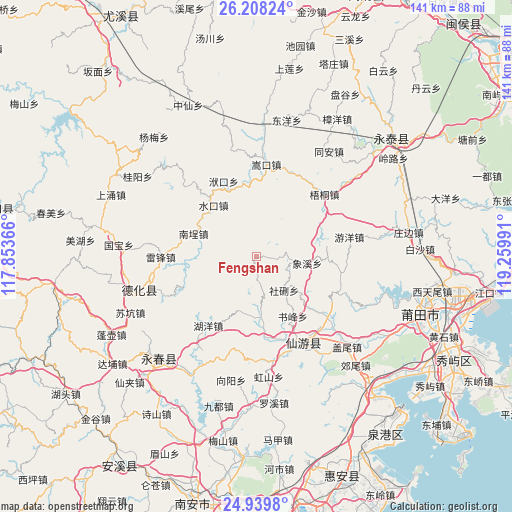
| Upper-left | 26.20824°, | 117.85366° |
| Center: | 25.5757°, | 118.55678° |
| Lower-right: | 24.9398°, | 119.25991° |
| Map W x H: | 141×141 km | = 87.6×87.6mi |
| max Lat: | 53.31946° ⇑84% North |
| Fengshan: | 25.5757° |
| min Lat: | ⇓16% South 18.22056° |
| min Long | Fengshan | max Long |
| 75.07348° | 118.55678° | 134.28917° |
| W 73.6%⇐ | ⇒26.4% E |
Elevation
Elevation of Fengshan is 958 m = 3143 ft, and this is 473.2 m = 1552 ft above average elevation for this country.
| Max E: |
5622 m = 18445 ft | 15.4% |
| Fengshan | 958 m 3143 ft | |
| Avg. | 484.8 m = 1591 ft | |
Min E: |
-3 m = -10 ft | 84.6% |
See also: China elevation on elevation.city.
Geographical zone
Fengshan is located in North temperate zone (between Tropic of Cancer and the Arctic Circle). Distance of this Northern Tropic circle is 237.8 km =147.8 mi to South.| Distance of | km | miles | from Fengshan |
|---|---|---|---|
| North Pole | 7163.3 | 4451.1 | to North |
| Arctic Circle | 4557.4 | 2831.8 | to North |
| Tropic Cancer | 237.8 | 147.8 | to South |
| Equator | 2843.8 | 1767.1 | to South |


Nearby cities:
15 places around Fengshan: (largest is in red/bold)
• Bangtou
25.3 km =15.7 mi,  130°
130°
• Daji
23.9 km =14.9 mi,  160°
160°
• Duwei
17.8 km =11.1 mi,  173°
173°
• Fukou
22.6 km =14 mi,  336°
336°
• Huyang
23.1 km =14.4 mi,  215°
215°
• Longmentan
23 km =14.3 mi,  249°
249°
• Nancheng
18.6 km =11.6 mi,  291°
291°
• Shexing
11.6 km =7.2 mi,  142°
142°
• Shicang
19.8 km =12.3 mi,  81°
81°
• Shufeng
19.3 km =12 mi,  148°
148°
• Shuikou
19.7 km =12.2 mi,  320°
320°
• Wutong
25.3 km =15.7 mi,  47°
47°
• Xiangxi
14.2 km =8.8 mi,  97°
97°
• Xiyuan
8.9 km =5.5 mi,  175°
175°
• Zhongshan
23.9 km =14.9 mi, 101°
Sources, notices
• [Note1] Compared only with cities in China existing in our database
• [Src1] Map data: © OpenStreetMap contributors (CC-BY-SA)
• [Src2] Other city data from geonames.org with taken over terms of usage.
• [Src3] Geographical zone / Annual Mean Temperature by Robert A. Rohde @ Wikipedia
