Dongping geodata
Dongping (Guangdong) is a seat of a fourth-order administrative division; located in China in Asia/Shanghai (GMT+8) time zone. In our database, there are 1268 cities with bigger population. Compared to other cities in China, 97.7% of cities are located further ↑North; 61.6% of cities are located further →East and 60.6% of cities have higher elevation than Dongping. Note1


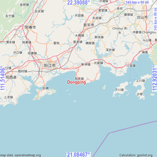
Dongping GPS coordinates[2]
21° 44' 21.336" North, 112° 13' 1.848" East
| Map corner | latitude | longitude |
|---|---|---|
| Upper-left | 22.39088°, | 111.51406° |
| Center: | 21.73926°, | 112.21718° |
| Lower-right: | 21.08467°, | 112.92031° |
| Map W x H: | 145.2×145.2 km | = 90.2×90.2mi |
| max Lat: | 53.31946° ⇑97.7% North |
| Dongping: | 21.73926° |
| min Lat: | ⇓2.3% South 18.22056° |
| min Long | Dongping | max Long |
| 75.07348° | 112.21718° | 134.28917° |
| W 38.4%⇐ | ⇒61.6% E |
Elevation
Elevation of Dongping is 95 m = 312 ft, and this is 389.8 m = 1279 ft below average elevation for this country.
| Max E: |
5622 m = 18445 ft | 60.6% |
| Avg. | 484.8 m = 1591 ft | |
| Dongping | 95 m = 312 ft | |
Min E: |
-3 m = -10 ft | 39.4% |
See also: China elevation on elevation.city.
Geographical zone
Dongping is located in North Torrid zone (between Equator and Tropic of Cancer). Distance of this Northern Tropic circle is 188.7 km =117.3 mi to North.| Distance of | km | miles | from Dongping |
|---|---|---|---|
| North Pole | 7589.9 | 4716.1 | to North |
| Arctic Circle | 4984 | 3096.9 | to North |
| Tropic Cancer | 188.7 | 117.3 | to North |
| Equator | 2417.2 | 1502 | to South |


Nearby cities:
15 places around Dongping: (largest is in red/bold)
• Beidou
23.4 km =14.5 mi,  49°
49°
• Beiguan
26.5 km =16.5 mi,  324°
324°
• Buchang
30.8 km =19.1 mi,  278°
278°
• Chengxi
30.4 km =18.9 mi,  288°
288°
• Dagou
12.3 km =7.6 mi,  329°
329°
• Dongcheng
26.6 km =16.5 mi,  306°
306°
• Ganglie
29 km =18 mi,  295°
295°
• Haiyan
35.1 km =21.8 mi,  73°
73°
• Hengpi
34.8 km =21.6 mi,  17°
17°
• Heshan
26.8 km =16.7 mi,  339°
339°
• Nalong
33.1 km =20.6 mi,  358°
358°
• Wencun
31.8 km =19.8 mi,  64°
64°
• Xinzhou
14.7 km =9.1 mi,  26°
26°
• Yangjiang
29.3 km =18.2 mi, 296°
• Yashao
19.7 km =12.2 mi, 297°
Sources, notices
• [Note1] Compared only with cities in China existing in our database
• [Src1] Map data: © OpenStreetMap contributors (CC-BY-SA)
• [Src2] Other city data from geonames.org with taken over terms of usage.
• [Src3] Geographical zone / Annual Mean Temperature by Robert A. Rohde @ Wikipedia
