Yangjiang geodata
Yangjiang (Guangdong) is a seat of a second-order administrative division; located in China in Asia/Shanghai (GMT+8) time zone. With population of 399,735 people, there are 152 cities with bigger population in this country. Compared to other cities in China, 97.5% of cities are located further ↑North; 62.9% of cities are located further →East and 85.5% of cities have higher elevation than Yangjiang. Note1


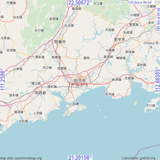
Yangjiang GPS coordinates[2]
21° 51' 20.268" North, 111° 57' 45.792" East
| Map corner | latitude | longitude |
|---|---|---|
| Upper-left | 22.50672°, | 111.2596° |
| Center: | 21.85563°, | 111.96272° |
| Lower-right: | 21.20156°, | 112.66585° |
| Map W x H: | 145.1×145.1 km | = 90.2×90.2mi |
| max Lat: | 53.31946° ⇑97.5% North |
| Yangjiang: | 21.85563° |
| min Lat: | ⇓2.5% South 18.22056° |
| min Long | Yangjiang | max Long |
| 75.07348° | 111.96272° | 134.28917° |
| W 37.1%⇐ | ⇒62.9% E |
Elevation
Elevation of Yangjiang is 15 m = 49 ft, and this is 469.8 m = 1541 ft below average elevation for this country.
| Max E: |
5622 m = 18445 ft | 85.5% |
| Avg. | 484.8 m = 1591 ft | |
| Yangjiang | 15 m = 49 ft | |
Min E: |
-3 m = -10 ft | 14.5% |
See also: Yangjiang elevation on elevation.city.
Geographical zone
Yangjiang is located in North Torrid zone (between Equator and Tropic of Cancer). Distance of this Northern Tropic circle is 175.8 km =109.2 mi to North.| Distance of | km | miles | from Yangjiang |
|---|---|---|---|
| North Pole | 7576.9 | 4708.1 | to North |
| Arctic Circle | 4971.1 | 3088.9 | to North |
| Tropic Cancer | 175.8 | 109.2 | to North |
| Equator | 2430.1 | 1510 | to South |


Nearby cities:
15 places around Yangjiang: (largest is in red/bold)
• Baisha
9.3 km =5.8 mi,  281°
281°
• Beiguan
13.7 km =8.5 mi,  51°
51°
• Buchang
9.5 km =5.9 mi,  205°
205°
• Chengcun
27.2 km =16.9 mi,  257°
257°
• Chengxi
4.2 km =2.6 mi,  217°
217°
• Daba
24.2 km =15 mi,  359°
359°
• Dagou
20.1 km =12.5 mi,  96°
96°
• Dongcheng
5.7 km =3.5 mi,  59°
59°
• Dongping
29.3 km =18.2 mi,  116°
116°
• Ganglie
0.7 km =0.4 mi,  178°
178°
• Heshan
21 km =13 mi, 54°
• Pinggang
14.2 km =8.8 mi, 218°
• Shuangjie
21.1 km =13.1 mi,  297°
297°
• Tangping
19.8 km =12.3 mi,  351°
351°
• Yashao
9.7 km =6 mi,  112°
112°
Sources, notices
• [Note1] Compared only with cities in China existing in our database
• [Src1] Map data: © OpenStreetMap contributors (CC-BY-SA)
• [Src2] Other city data from geonames.org with taken over terms of usage.
• [Src3] Geographical zone / Annual Mean Temperature by Robert A. Rohde @ Wikipedia
