Dongkengkou geodata
Dongkengkou (Zhejiang) is a seat of a fourth-order administrative division; located in China in Asia/Shanghai (GMT+8) time zone. In our database, there are 1268 cities with bigger population. Compared to other cities in China, 64.8% of cities are located further ↑North; 71.2% of cities are located further ←West and 56.3% of cities have lower elevation than Dongkengkou. Note1


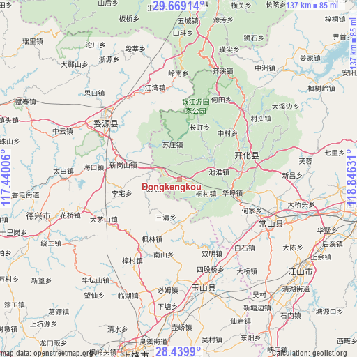
Dongkengkou GPS coordinates[2]
29° 3' 22.86" North, 118° 8' 35.448" East
| Map corner | latitude | longitude |
|---|---|---|
| Upper-left | 29.66914°, | 117.44006° |
| Center: | 29.05635°, | 118.14318° |
| Lower-right: | 28.4399°, | 118.84631° |
| Map W x H: | 136.7×136.7 km | = 84.9×84.9mi |
| max Lat: | 53.31946° ⇑64.8% North |
| Dongkengkou: | 29.05635° |
| min Lat: | ⇓35.2% South 18.22056° |
| min Long | Dongkengkou | max Long |
| 75.07348° | 118.14318° | 134.28917° |
| W 71.2%⇐ | ⇒28.8% E |
Elevation
Elevation of Dongkengkou is 219 m = 719 ft, and this is 265.8 m = 872 ft below average elevation for this country.
| Max E: |
5622 m = 18445 ft | 43.7% |
| Avg. | 484.8 m = 1591 ft | |
| Dongkengkou | 219 m = 719 ft | |
Min E: |
-3 m = -10 ft | 56.3% |
See also: China elevation on elevation.city.
Geographical zone
Dongkengkou is located in North temperate zone (between Tropic of Cancer and the Arctic Circle). Distance of this Northern Tropic circle is 624.8 km =388.2 mi to South.| Distance of | km | miles | from Dongkengkou |
|---|---|---|---|
| North Pole | 6776.3 | 4210.6 | to North |
| Arctic Circle | 4170.4 | 2591.4 | to North |
| Tropic Cancer | 624.8 | 388.2 | to South |
| Equator | 3230.8 | 2007.5 | to South |


Nearby cities:
15 places around Dongkengkou: (largest is in red/bold)
• Fangcun
22.6 km =14 mi,  24°
24°
• Fengjia
26.8 km =16.7 mi,  99°
99°
• Huabu
20.4 km =12.7 mi, 102°
• Lizhai
22.4 km =13.9 mi,  256°
256°
• Lujiawu
11.6 km =7.2 mi,  117°
117°
• Maotan
13.7 km =8.5 mi,  351°
351°
• Qingshandi
24.6 km =15.3 mi,  82°
82°
• Sanqing
15.3 km =9.5 mi,  198°
198°
• Wenshan
21.7 km =13.5 mi,  67°
67°
• Xingangshan
20.2 km =12.6 mi,  285°
285°
• Xingkou
15.6 km =9.7 mi, 79°
• Xinjian
21.6 km =13.4 mi, 290°
• Youxikou
9.2 km =5.7 mi,  34°
34°
• Zhangcun
26 km =16.2 mi,  45°
45°
• Zihu
16.8 km =10.4 mi,  176°
176°
Sources, notices
• [Note1] Compared only with cities in China existing in our database
• [Src1] Map data: © OpenStreetMap contributors (CC-BY-SA)
• [Src2] Other city data from geonames.org with taken over terms of usage.
• [Src3] Geographical zone / Annual Mean Temperature by Robert A. Rohde @ Wikipedia
