Donggou geodata
Donggou (Jiangsu) is a seat of a fourth-order administrative division; located in China in Asia/Shanghai (GMT+8) time zone. In our database, there are 1268 cities with bigger population. Compared to other cities in China, 62.9% of cities are located further ↓South; 76% of cities are located further ←West and 89.9% of cities have higher elevation than Donggou. Note1


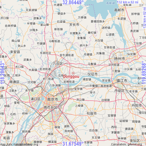
Donggou GPS coordinates[2]
32° 16' 18.984" North, 118° 59' 22.38" East
| Map corner | latitude | longitude |
|---|---|---|
| Upper-left | 32.86449°, | 118.28643° |
| Center: | 32.27194°, | 118.98955° |
| Lower-right: | 31.67549°, | 119.69268° |
| Map W x H: | 132.2×132.2 km | = 82.1×82.1mi |
| max Lat: | 53.31946° ⇑37.1% North |
| Donggou: | 32.27194° |
| min Lat: | ⇓62.9% South 18.22056° |
| min Long | Donggou | max Long |
| 75.07348° | 118.98955° | 134.28917° |
| W 76%⇐ | ⇒24% E |
Elevation
Elevation of Donggou is 10 m = 33 ft, and this is 474.8 m = 1558 ft below average elevation for this country.
| Max E: |
5622 m = 18445 ft | 89.9% |
| Avg. | 484.8 m = 1591 ft | |
| Donggou | 10 m = 33 ft | |
Min E: |
-3 m = -10 ft | 10.1% |
See also: China elevation on elevation.city.
Geographical zone
Donggou is located in North temperate zone (between Tropic of Cancer and the Arctic Circle). Distance of this Northern Tropic circle is 982.4 km =610.4 mi to South.| Distance of | km | miles | from Donggou |
|---|---|---|---|
| North Pole | 6418.8 | 3988.5 | to North |
| Arctic Circle | 3812.9 | 2369.2 | to North |
| Tropic Cancer | 982.4 | 610.4 | to South |
| Equator | 3588.3 | 2229.7 | to South |


Nearby cities:
15 places around Donggou: (largest is in red/bold)
• Babaiqiao
17.5 km =10.9 mi,  340°
340°
• Baohua
14.7 km =9.1 mi,  162°
162°
• Guabu
10.2 km =6.3 mi,  255°
255°
• Hengliang
8.2 km =5.1 mi,  317°
317°
• Hongmiao
8.4 km =5.2 mi,  231°
231°
• Jing’an
15.2 km =9.4 mi,  108°
108°
• Longpao
9 km =5.6 mi,  204°
204°
• Longtan
12.8 km =8 mi,  154°
154°
• Qingshan
8.2 km =5.1 mi, 105°
• Qixia
15.5 km =9.6 mi, 196°
• Xinhuang
12.4 km =7.7 mi, 337°
• Xiongzhou
15.4 km =9.6 mi,  301°
301°
• Yudai
9.6 km =6 mi,  237°
237°
• Yuetang
17 km =10.6 mi,  29°
29°
• Zhenzhou
17 km =10.6 mi,  86°
86°
Sources, notices
• [Note1] Compared only with cities in China existing in our database
• [Src1] Map data: © OpenStreetMap contributors (CC-BY-SA)
• [Src2] Other city data from geonames.org with taken over terms of usage.
• [Src3] Geographical zone / Annual Mean Temperature by Robert A. Rohde @ Wikipedia
