Qixia geodata
Qixia (Jiangsu) is a seat of a fourth-order administrative division; located in China in Asia/Shanghai (GMT+8) time zone. In our database, there are 1268 cities with bigger population. Compared to other cities in China, 62.1% of cities are located further ↓South; 75.8% of cities are located further ←West and 89.9% of cities have higher elevation than Qixia. Note1


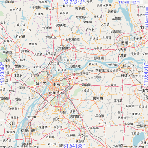
Qixia GPS coordinates[2]
32° 8' 19.32" North, 118° 56' 31.344" East
| Map corner | latitude | longitude |
|---|---|---|
| Upper-left | 32.73213°, | 118.23892° |
| Center: | 32.1387°, | 118.94204° |
| Lower-right: | 31.54138°, | 119.64517° |
| Map W x H: | 132.4×132.4 km | = 82.3×82.3mi |
| max Lat: | 53.31946° ⇑37.9% North |
| Qixia: | 32.1387° |
| min Lat: | ⇓62.1% South 18.22056° |
| min Long | Qixia | max Long |
| 75.07348° | 118.94204° | 134.28917° |
| W 75.8%⇐ | ⇒24.2% E |
Elevation
Elevation of Qixia is 10 m = 33 ft, and this is 474.8 m = 1558 ft below average elevation for this country.
| Max E: |
5622 m = 18445 ft | 89.9% |
| Avg. | 484.8 m = 1591 ft | |
| Qixia | 10 m = 33 ft | |
Min E: |
-3 m = -10 ft | 10.1% |
See also: China elevation on elevation.city.
Geographical zone
Qixia is located in North temperate zone (between Tropic of Cancer and the Arctic Circle). Distance of this Northern Tropic circle is 967.6 km =601.2 mi to South.| Distance of | km | miles | from Qixia |
|---|---|---|---|
| North Pole | 6433.6 | 3997.7 | to North |
| Arctic Circle | 3827.7 | 2378.4 | to North |
| Tropic Cancer | 967.6 | 601.2 | to South |
| Equator | 3573.5 | 2220.5 | to South |


Nearby cities:
15 places around Qixia: (largest is in red/bold)
• Baguazhou
12.4 km =7.7 mi,  288°
288°
• Baohua
9 km =5.6 mi,  85°
85°
• Donggou
15.5 km =9.6 mi,  16°
16°
• Guabu
13.4 km =8.3 mi,  336°
336°
• Hongmiao
9.8 km =6.1 mi,  347°
347°
• Longpao
6.7 km =4.2 mi,  6°
6°
• Longtan
10.6 km =6.6 mi,  72°
72°
• Ma’qun
10.6 km =6.6 mi,  208°
208°
• Meiyuan Xincun
16.9 km =10.5 mi,  236°
236°
• Mufushan
16.2 km =10.1 mi,  260°
260°
• Xiaolingwei
14.4 km =8.9 mi,  215°
215°
• Xiaoshi
15.8 km =9.8 mi,  253°
253°
• Yanziji
11.6 km =7.2 mi,  272°
272°
• Yaohua
6.9 km =4.3 mi, 253°
• Yudai
10.4 km =6.5 mi, 339°
Sources, notices
• [Note1] Compared only with cities in China existing in our database
• [Src1] Map data: © OpenStreetMap contributors (CC-BY-SA)
• [Src2] Other city data from geonames.org with taken over terms of usage.
• [Src3] Geographical zone / Annual Mean Temperature by Robert A. Rohde @ Wikipedia
