Zhenzhou geodata
Zhenzhou (Jiangsu) is a seat of a third-order administrative division; located in China in Asia/Shanghai (GMT+8) time zone. With population of 176,006 people, there are 254 cities with bigger population in this country. Compared to other cities in China, 62.9% of cities are located further ↓South; 76.9% of cities are located further ←West and 89.9% of cities have higher elevation than Zhenzhou. Note1


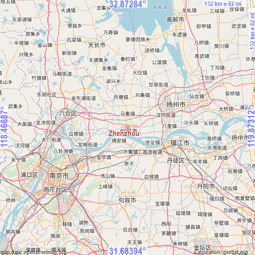
Zhenzhou GPS coordinates[2]
32° 16' 49.224" North, 119° 10' 11.964" East
| Map corner | latitude | longitude |
|---|---|---|
| Upper-left | 32.87284°, | 118.46687° |
| Center: | 32.28034°, | 119.16999° |
| Lower-right: | 31.68394°, | 119.87312° |
| Map W x H: | 132.2×132.2 km | = 82.1×82.1mi |
| max Lat: | 53.31946° ⇑37.1% North |
| Zhenzhou: | 32.28034° |
| min Lat: | ⇓62.9% South 18.22056° |
| min Long | Zhenzhou | max Long |
| 75.07348° | 119.16999° | 134.28917° |
| W 76.9%⇐ | ⇒23.1% E |
Elevation
Elevation of Zhenzhou is 10 m = 33 ft, and this is 474.8 m = 1558 ft below average elevation for this country.
| Max E: |
5622 m = 18445 ft | 89.9% |
| Avg. | 484.8 m = 1591 ft | |
| Zhenzhou | 10 m = 33 ft | |
Min E: |
-3 m = -10 ft | 10.1% |
See also: Zhenzhou elevation on elevation.city.
Geographical zone
Zhenzhou is located in North temperate zone (between Tropic of Cancer and the Arctic Circle). Distance of this Northern Tropic circle is 983.3 km =611 mi to South.| Distance of | km | miles | from Zhenzhou |
|---|---|---|---|
| North Pole | 6417.8 | 3987.8 | to North |
| Arctic Circle | 3811.9 | 2368.6 | to North |
| Tropic Cancer | 983.3 | 611 | to South |
| Equator | 3589.2 | 2230.2 | to South |


Nearby cities:
15 places around Zhenzhou: (largest is in red/bold)
• Baohua
19.5 km =12.1 mi,  219°
219°
• Donggou
17 km =10.6 mi,  266°
266°
• Gaozi
17.5 km =10.9 mi,  134°
134°
• Jing’an
6.3 km =3.9 mi,  203°
203°
• Liuji
18.7 km =11.6 mi,  23°
23°
• Longtan
16.9 km =10.5 mi, 222°
• Maji
8.3 km =5.2 mi,  358°
358°
• Poxi
13.7 km =8.5 mi,  82°
82°
• Qingshan
9.6 km =6 mi,  251°
251°
• Shiye
14.6 km =9.1 mi,  120°
120°
• Xiashu
12 km =7.5 mi,  172°
172°
• Xieji
16.6 km =10.3 mi,  347°
347°
• Xincheng
6 km =3.7 mi, 82°
• Xinji
12.7 km =7.9 mi,  65°
65°
• Yuetang
16.2 km =10.1 mi,  328°
328°
Sources, notices
• [Note1] Compared only with cities in China existing in our database
• [Src1] Map data: © OpenStreetMap contributors (CC-BY-SA)
• [Src2] Other city data from geonames.org with taken over terms of usage.
• [Src3] Geographical zone / Annual Mean Temperature by Robert A. Rohde @ Wikipedia
