Xiaoqiao geodata
Xiaoqiao (Fujian) is a seat of a fourth-order administrative division; located in China in Asia/Shanghai (GMT+8) time zone. In our database, there are 1268 cities with bigger population. Compared to other cities in China, 78.8% of cities are located further ↑North; 73% of cities are located further ←West and 52.7% of cities have higher elevation than Xiaoqiao. Note1


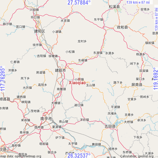
Xiaoqiao GPS coordinates[2]
26° 57' 13.86" North, 118° 27' 57.852" East
| Map corner | latitude | longitude |
|---|---|---|
| Upper-left | 27.57884°, | 117.76295° |
| Center: | 26.95385°, | 118.46607° |
| Lower-right: | 26.32537°, | 119.1692° |
| Map W x H: | 139.4×139.4 km | = 86.6×86.6mi |
| max Lat: | 53.31946° ⇑78.8% North |
| Xiaoqiao: | 26.95385° |
| min Lat: | ⇓21.2% South 18.22056° |
| min Long | Xiaoqiao | max Long |
| 75.07348° | 118.46607° | 134.28917° |
| W 73%⇐ | ⇒27% E |
Elevation
Elevation of Xiaoqiao is 145 m = 476 ft, and this is 339.8 m = 1115 ft below average elevation for this country.
| Max E: |
5622 m = 18445 ft | 52.7% |
| Avg. | 484.8 m = 1591 ft | |
| Xiaoqiao | 145 m = 476 ft | |
Min E: |
-3 m = -10 ft | 47.3% |
See also: China elevation on elevation.city.
Geographical zone
Xiaoqiao is located in North temperate zone (between Tropic of Cancer and the Arctic Circle). Distance of this Northern Tropic circle is 391.1 km =243 mi to South.| Distance of | km | miles | from Xiaoqiao |
|---|---|---|---|
| North Pole | 7010.1 | 4355.9 | to North |
| Arctic Circle | 4404.2 | 2736.6 | to North |
| Tropic Cancer | 391.1 | 243 | to South |
| Equator | 2997 | 1862.2 | to South |


Nearby cities:
15 places around Xiaoqiao: (largest is in red/bold)
• Daheng
29.3 km =18.2 mi,  224°
224°
• Dikou
22.7 km =14.1 mi,  180°
180°
• Dongfeng
16.8 km =10.4 mi,  10°
10°
• Dongyou
28.4 km =17.6 mi,  35°
35°
• Jian’ou
17.4 km =10.8 mi,  306°
306°
• Longcun
33.4 km =20.8 mi,  4°
4°
• Luxia
33.9 km =21.1 mi,  94°
94°
• Nanya
17.9 km =11.1 mi,  241°
241°
• Ouning
17.6 km =10.9 mi,  299°
299°
• Shunyang
19.9 km =12.4 mi, 37°
• Xiaosong
25.3 km =15.7 mi,  341°
341°
• Yanghou
35.1 km =21.8 mi,  173°
173°
• Yedun
32.5 km =20.2 mi,  261°
261°
• Yushan
11.2 km =7 mi,  116°
116°
• Zhishan
17.2 km =10.7 mi, 305°
Sources, notices
• [Note1] Compared only with cities in China existing in our database
• [Src1] Map data: © OpenStreetMap contributors (CC-BY-SA)
• [Src2] Other city data from geonames.org with taken over terms of usage.
• [Src3] Geographical zone / Annual Mean Temperature by Robert A. Rohde @ Wikipedia
