Dengzhou geodata
Dengzhou (Shandong) is a seat of a third-order administrative division; located in China in Asia/Shanghai (GMT+8) time zone. With population of 85,279 people, there are 500 cities with bigger population in this country. Compared to other cities in China, 80.7% of cities are located further ↓South; 86.6% of cities are located further ←West and 81.6% of cities have higher elevation than Dengzhou. Note1


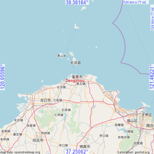
Dengzhou GPS coordinates[2]
37° 48' 29.592" North, 120° 45' 32.688" East
| Map corner | latitude | longitude |
|---|---|---|
| Upper-left | 38.36164°, | 120.05596° |
| Center: | 37.80822°, | 120.75908° |
| Lower-right: | 37.25062°, | 121.46221° |
| Map W x H: | 123.5×123.5 km | = 76.7×76.7mi |
| max Lat: | 53.31946° ⇑19.3% North |
| Dengzhou: | 37.80822° |
| min Lat: | ⇓80.7% South 18.22056° |
| min Long | Dengzhou | max Long |
| 75.07348° | 120.75908° | 134.28917° |
| W 86.6%⇐ | ⇒13.4% E |
Elevation
Elevation of Dengzhou is 23 m = 75 ft, and this is 461.8 m = 1515 ft below average elevation for this country.
| Max E: |
5622 m = 18445 ft | 81.6% |
| Avg. | 484.8 m = 1591 ft | |
| Dengzhou | 23 m = 75 ft | |
Min E: |
-3 m = -10 ft | 18.4% |
See also: Dengzhou elevation on elevation.city.
Geographical zone
Dengzhou is located in North temperate zone (between Tropic of Cancer and the Arctic Circle). Distance of this Northern Tropic circle is 1598 km =993 mi to South.| Distance of | km | miles | from Dengzhou |
|---|---|---|---|
| North Pole | 5803.2 | 3605.9 | to North |
| Arctic Circle | 3197.3 | 1986.7 | to North |
| Tropic Cancer | 1598 | 993 | to South |
| Equator | 4203.9 | 2612.2 | to South |


Nearby cities:
15 places around Dengzhou: (largest is in red/bold)
• Beichangshan
17.8 km =11.1 mi,  349°
349°
• Beigou
14.9 km =9.3 mi,  238°
238°
• Chaoshui
22.7 km =14.1 mi,  124°
124°
• Daxindian
22.3 km =13.9 mi,  158°
158°
• Donglai
27.4 km =17 mi,  229°
229°
• Heishan
21.3 km =13.2 mi,  325°
325°
• Langao
23.9 km =14.9 mi,  219°
219°
• Liujiagou
12 km =7.5 mi,  112°
112°
• Nanchangshan
12.1 km =7.5 mi, 348°
• Nanchangshan
13.8 km =8.6 mi, 349°
• Nanwang
5.8 km =3.6 mi,  149°
149°
• Shiliang
27.1 km =16.8 mi,  198°
198°
• Xiaomenjia
20.4 km =12.7 mi,  170°
170°
• Xingang
10 km =6.2 mi,  98°
98°
• Zhuyouguan
20.4 km =12.7 mi, 229°
Sources, notices
• [Note1] Compared only with cities in China existing in our database
• [Src1] Map data: © OpenStreetMap contributors (CC-BY-SA)
• [Src2] Other city data from geonames.org with taken over terms of usage.
• [Src3] Geographical zone / Annual Mean Temperature by Robert A. Rohde @ Wikipedia
