Dayin geodata
Dayin (Zhejiang) is a seat of a fourth-order administrative division; located in China in Asia/Shanghai (GMT+8) time zone. In our database, there are 1268 cities with bigger population. Compared to other cities in China, 54.6% of cities are located further ↑North; 89.4% of cities are located further ←West and 99.7% of cities have higher elevation than Dayin. Note1


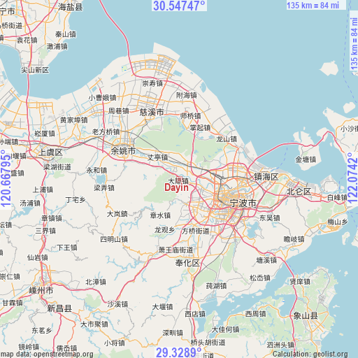
Dayin GPS coordinates[2]
29° 56' 24.18" North, 121° 22' 15.852" East
| Map corner | latitude | longitude |
|---|---|---|
| Upper-left | 30.54747°, | 120.66795° |
| Center: | 29.94005°, | 121.37107° |
| Lower-right: | 29.3289°, | 122.0742° |
| Map W x H: | 135.5×135.5 km | = 84.2×84.2mi |
| max Lat: | 53.31946° ⇑54.6% North |
| Dayin: | 29.94005° |
| min Lat: | ⇓45.4% South 18.22056° |
| min Long | Dayin | max Long |
| 75.07348° | 121.37107° | 134.28917° |
| W 89.4%⇐ | ⇒10.6% E |
Elevation
Elevation of Dayin is 1 m = 3 ft, and this is 483.8 m = 1587 ft below average elevation for this country.
| Max E: |
5622 m = 18445 ft | 99.7% |
| Avg. | 484.8 m = 1591 ft | |
| Dayin | 1 m = 3 ft | |
Min E: |
-3 m = -10 ft | 0.3% |
See also: China elevation on elevation.city.
Geographical zone
Dayin is located in North temperate zone (between Tropic of Cancer and the Arctic Circle). Distance of this Northern Tropic circle is 723.1 km =449.3 mi to South.| Distance of | km | miles | from Dayin |
|---|---|---|---|
| North Pole | 6678 | 4149.5 | to North |
| Arctic Circle | 4072.2 | 2530.3 | to North |
| Tropic Cancer | 723.1 | 449.3 | to South |
| Equator | 3329 | 2068.5 | to South |


Nearby cities:
15 places around Dayin: (largest is in red/bold)
• Cicheng
8.1 km =5 mi,  54°
54°
• Dongqiao
18 km =11.2 mi,  170°
170°
• Duantang
17.8 km =11.1 mi,  123°
123°
• Gaoqiao
8.8 km =5.5 mi,  113°
113°
• Hemudu
7.8 km =4.8 mi,  312°
312°
• Hengjie
9.3 km =5.8 mi,  164°
164°
• Hongtang
13.1 km =8.1 mi,  84°
84°
• Jishigang
9.7 km =6 mi,  143°
143°
• Lubu
14.7 km =9.1 mi,  292°
292°
• Ningbo
18.5 km =11.5 mi, 111°
• Sanqishi
10.9 km =6.8 mi,  343°
343°
• Shiqi
18.3 km =11.4 mi, 135°
• Zhangshui
15 km =9.3 mi,  207°
207°
• Zhangting
11.8 km =7.3 mi,  315°
315°
• Zhuangqiao
17.1 km =10.6 mi,  93°
93°
Sources, notices
• [Note1] Compared only with cities in China existing in our database
• [Src1] Map data: © OpenStreetMap contributors (CC-BY-SA)
• [Src2] Other city data from geonames.org with taken over terms of usage.
• [Src3] Geographical zone / Annual Mean Temperature by Robert A. Rohde @ Wikipedia
