Hemudu geodata
Hemudu (Zhejiang) is a seat of a fourth-order administrative division; located in China in Asia/Shanghai (GMT+8) time zone. In our database, there are 1268 cities with bigger population. Compared to other cities in China, 54.2% of cities are located further ↑North; 89.1% of cities are located further ←West and 97.2% of cities have higher elevation than Hemudu. Note1


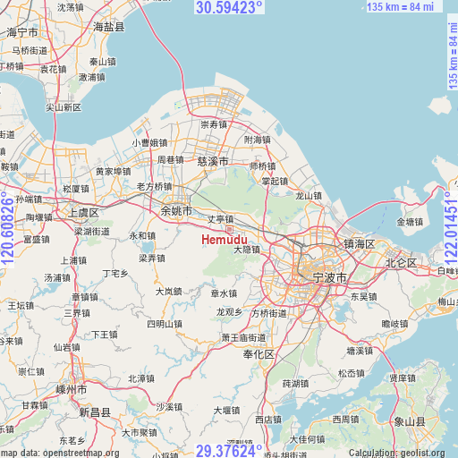
Hemudu GPS coordinates[2]
29° 59' 13.56" North, 121° 18' 40.968" East
| Map corner | latitude | longitude |
|---|---|---|
| Upper-left | 30.59423°, | 120.60826° |
| Center: | 29.9871°, | 121.31138° |
| Lower-right: | 29.37624°, | 122.01451° |
| Map W x H: | 135.4×135.4 km | = 84.1×84.1mi |
| max Lat: | 53.31946° ⇑54.2% North |
| Hemudu: | 29.9871° |
| min Lat: | ⇓45.8% South 18.22056° |
| min Long | Hemudu | max Long |
| 75.07348° | 121.31138° | 134.28917° |
| W 89.1%⇐ | ⇒10.9% E |
Elevation
Elevation of Hemudu is 5 m = 16 ft, and this is 479.8 m = 1574 ft below average elevation for this country.
| Max E: |
5622 m = 18445 ft | 97.2% |
| Avg. | 484.8 m = 1591 ft | |
| Hemudu | 5 m = 16 ft | |
Min E: |
-3 m = -10 ft | 2.8% |
See also: China elevation on elevation.city.
Geographical zone
Hemudu is located in North temperate zone (between Tropic of Cancer and the Arctic Circle). Distance of this Northern Tropic circle is 728.3 km =452.5 mi to South.| Distance of | km | miles | from Hemudu |
|---|---|---|---|
| North Pole | 6672.8 | 4146.3 | to North |
| Arctic Circle | 4066.9 | 2527.1 | to North |
| Tropic Cancer | 728.3 | 452.5 | to South |
| Equator | 3334.3 | 2071.8 | to South |


Nearby cities:
15 places around Hemudu: (largest is in red/bold)
• Cicheng
12.4 km =7.7 mi,  92°
92°
• Dayin
7.8 km =4.8 mi,  132°
132°
• Gaoqiao
16.3 km =10.1 mi,  122°
122°
• Henghe
17.4 km =10.8 mi,  335°
335°
• Hengjie
16.4 km =10.2 mi,  149°
149°
• Hongtang
19.2 km =11.9 mi,  101°
101°
• Jishigang
17.4 km =10.8 mi,  138°
138°
• Kuangyan
18.3 km =11.4 mi,  355°
355°
• Lubu
7.8 km =4.8 mi,  272°
272°
• Qiaotou
19.8 km =12.3 mi,  12°
12°
• Sanqishi
5.8 km =3.6 mi,  26°
26°
• Yuyao
17.1 km =10.6 mi,  294°
294°
• Zhangqi
19.6 km =12.2 mi,  43°
43°
• Zhangshui
18.6 km =11.6 mi,  183°
183°
• Zhangting
4.1 km =2.5 mi,  320°
320°
Sources, notices
• [Note1] Compared only with cities in China existing in our database
• [Src1] Map data: © OpenStreetMap contributors (CC-BY-SA)
• [Src2] Other city data from geonames.org with taken over terms of usage.
• [Src3] Geographical zone / Annual Mean Temperature by Robert A. Rohde @ Wikipedia
