Zhangshui geodata
Zhangshui (Zhejiang) is a seat of a fourth-order administrative division; located in China in Asia/Shanghai (GMT+8) time zone. In our database, there are 1268 cities with bigger population. Compared to other cities in China, 56.1% of cities are located further ↑North; 89.1% of cities are located further ←West and 82.4% of cities have higher elevation than Zhangshui. Note1


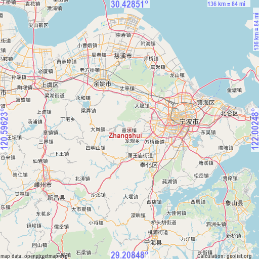
Zhangshui GPS coordinates[2]
29° 49' 13.296" North, 121° 17' 57.66" East
| Map corner | latitude | longitude |
|---|---|---|
| Upper-left | 30.42851°, | 120.59623° |
| Center: | 29.82036°, | 121.29935° |
| Lower-right: | 29.20848°, | 122.00248° |
| Map W x H: | 135.7×135.7 km | = 84.3×84.3mi |
| max Lat: | 53.31946° ⇑56.1% North |
| Zhangshui: | 29.82036° |
| min Lat: | ⇓43.9% South 18.22056° |
| min Long | Zhangshui | max Long |
| 75.07348° | 121.29935° | 134.28917° |
| W 89.1%⇐ | ⇒10.9% E |
Elevation
Elevation of Zhangshui is 21 m = 69 ft, and this is 463.8 m = 1522 ft below average elevation for this country.
| Max E: |
5622 m = 18445 ft | 82.4% |
| Avg. | 484.8 m = 1591 ft | |
| Zhangshui | 21 m = 69 ft | |
Min E: |
-3 m = -10 ft | 17.6% |
See also: China elevation on elevation.city.
Geographical zone
Zhangshui is located in North temperate zone (between Tropic of Cancer and the Arctic Circle). Distance of this Northern Tropic circle is 709.8 km =441 mi to South.| Distance of | km | miles | from Zhangshui |
|---|---|---|---|
| North Pole | 6691.3 | 4157.8 | to North |
| Arctic Circle | 4085.5 | 2538.6 | to North |
| Tropic Cancer | 709.8 | 441 | to South |
| Equator | 3315.7 | 2060.3 | to South |


Nearby cities:
15 places around Zhangshui: (largest is in red/bold)
• Dayin
15 km =9.3 mi,  27°
27°
• Dongqiao
10.9 km =6.8 mi,  113°
113°
• Gaoqiao
17.8 km =11.1 mi,  56°
56°
• Hemudu
18.6 km =11.6 mi,  3°
3°
• Hengjie
10.4 km =6.5 mi,  65°
65°
• Jiangkou
14 km =8.7 mi,  134°
134°
• Jinping
20.1 km =12.5 mi,  150°
150°
• Jishigang
13.9 km =8.6 mi, 66°
• Lubu
20.1 km =12.5 mi,  340°
340°
• Maoshan
20.7 km =12.9 mi, 113°
• Shiqi
19.8 km =12.3 mi,  89°
89°
• Simingshan
20.5 km =12.7 mi,  242°
242°
• Xiaowangmiao
14.3 km =8.9 mi,  157°
157°
• Xikou
15.2 km =9.4 mi,  189°
189°
• Yinjiang
7.4 km =4.6 mi, 133°
Sources, notices
• [Note1] Compared only with cities in China existing in our database
• [Src1] Map data: © OpenStreetMap contributors (CC-BY-SA)
• [Src2] Other city data from geonames.org with taken over terms of usage.
• [Src3] Geographical zone / Annual Mean Temperature by Robert A. Rohde @ Wikipedia
