Dalun geodata
Dalun (Jiangsu) is a seat of a fourth-order administrative division; located in China in Asia/Shanghai (GMT+8) time zone. In our database, there are 1268 cities with bigger population. Compared to other cities in China, 63.7% of cities are located further ↓South; 83.5% of cities are located further ←West and 97.2% of cities have higher elevation than Dalun. Note1


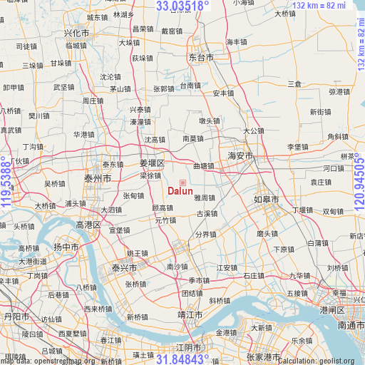
Dalun GPS coordinates[2]
32° 26' 37.536" North, 120° 14' 30.912" East
| Map corner | latitude | longitude |
|---|---|---|
| Upper-left | 33.03518°, | 119.5388° |
| Center: | 32.44376°, | 120.24192° |
| Lower-right: | 31.84843°, | 120.94505° |
| Map W x H: | 132×132 km | = 82×82mi |
| max Lat: | 53.31946° ⇑36.3% North |
| Dalun: | 32.44376° |
| min Lat: | ⇓63.7% South 18.22056° |
| min Long | Dalun | max Long |
| 75.07348° | 120.24192° | 134.28917° |
| W 83.5%⇐ | ⇒16.5% E |
Elevation
Elevation of Dalun is 5 m = 16 ft, and this is 479.8 m = 1574 ft below average elevation for this country.
| Max E: |
5622 m = 18445 ft | 97.2% |
| Avg. | 484.8 m = 1591 ft | |
| Dalun | 5 m = 16 ft | |
Min E: |
-3 m = -10 ft | 2.8% |
See also: China elevation on elevation.city.
Geographical zone
Dalun is located in North temperate zone (between Tropic of Cancer and the Arctic Circle). Distance of this Northern Tropic circle is 1001.5 km =622.3 mi to South.| Distance of | km | miles | from Dalun |
|---|---|---|---|
| North Pole | 6399.7 | 3976.6 | to North |
| Arctic Circle | 3793.8 | 2357.4 | to North |
| Tropic Cancer | 1001.5 | 622.3 | to South |
| Equator | 3607.4 | 2241.5 | to South |


Nearby cities:
15 places around Dalun: (largest is in red/bold)
• Baimi
7 km =4.3 mi,  7°
7°
• Gugao
11.5 km =7.1 mi,  219°
219°
• Guxi
13.9 km =8.6 mi,  141°
141°
• Hengduo
14.6 km =9.1 mi,  167°
167°
• Huji
15.5 km =9.6 mi,  58°
58°
• Jiangduo
8.6 km =5.3 mi,  180°
180°
• Jiangyan
11.6 km =7.2 mi,  306°
306°
• Liangxu
12.4 km =7.7 mi,  283°
283°
• Louzhuang
12.7 km =7.9 mi,  351°
351°
• Nanmo
17.1 km =10.6 mi, 11°
• Qutang
9.9 km =6.2 mi,  53°
53°
• Sunzhuang
14.1 km =8.8 mi,  92°
92°
• Xinjie
17.2 km =10.7 mi,  226°
226°
• Yazhou
9.6 km =6 mi,  122°
122°
• Yuanzhu
14.7 km =9.1 mi,  205°
205°
Sources, notices
• [Note1] Compared only with cities in China existing in our database
• [Src1] Map data: © OpenStreetMap contributors (CC-BY-SA)
• [Src2] Other city data from geonames.org with taken over terms of usage.
• [Src3] Geographical zone / Annual Mean Temperature by Robert A. Rohde @ Wikipedia
