Yuanzhu geodata
Yuanzhu (Jiangsu) is a seat of a fourth-order administrative division; located in China in Asia/Shanghai (GMT+8) time zone. In our database, there are 1268 cities with bigger population. Compared to other cities in China, 63.1% of cities are located further ↓South; 83.1% of cities are located further ←West and 94.3% of cities have higher elevation than Yuanzhu. Note1


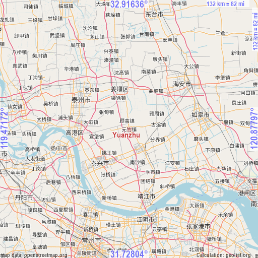
Yuanzhu GPS coordinates[2]
32° 19' 26.94" North, 120° 10' 29.424" East
| Map corner | latitude | longitude |
|---|---|---|
| Upper-left | 32.91636°, | 119.47172° |
| Center: | 32.32415°, | 120.17484° |
| Lower-right: | 31.72804°, | 120.87797° |
| Map W x H: | 132.1×132.1 km | = 82.1×82.1mi |
| max Lat: | 53.31946° ⇑36.9% North |
| Yuanzhu: | 32.32415° |
| min Lat: | ⇓63.1% South 18.22056° |
| min Long | Yuanzhu | max Long |
| 75.07348° | 120.17484° | 134.28917° |
| W 83.1%⇐ | ⇒16.9% E |
Elevation
Elevation of Yuanzhu is 7 m = 23 ft, and this is 477.8 m = 1568 ft below average elevation for this country.
| Max E: |
5622 m = 18445 ft | 94.3% |
| Avg. | 484.8 m = 1591 ft | |
| Yuanzhu | 7 m = 23 ft | |
Min E: |
-3 m = -10 ft | 5.7% |
See also: China elevation on elevation.city.
Geographical zone
Yuanzhu is located in North temperate zone (between Tropic of Cancer and the Arctic Circle). Distance of this Northern Tropic circle is 988.2 km =614 mi to South.| Distance of | km | miles | from Yuanzhu |
|---|---|---|---|
| North Pole | 6413 | 3984.9 | to North |
| Arctic Circle | 3807.1 | 2365.6 | to North |
| Tropic Cancer | 988.2 | 614 | to South |
| Equator | 3594.1 | 2233.3 | to South |


Nearby cities:
15 places around Yuanzhu: (largest is in red/bold)
• Dalun
14.7 km =9.1 mi,  25°
25°
• Fenjie
15.5 km =9.6 mi,  109°
109°
• Gugao
4.6 km =2.9 mi,  346°
346°
• Guxi
15.2 km =9.4 mi,  80°
80°
• Hengduo
9.6 km =6 mi,  95°
95°
• Heshi
13.6 km =8.5 mi,  195°
195°
• Huangqiao
10.8 km =6.7 mi,  149°
149°
• Huzhuang
14.7 km =9.1 mi,  282°
282°
• Jiangduo
7.8 km =4.8 mi,  53°
53°
• Liuchen
6.8 km =4.2 mi, 200°
• Xinjie
6.2 km =3.9 mi, 282°
• Xiqiao
11 km =6.8 mi,  176°
176°
• Yaowang
15.7 km =9.8 mi,  220°
220°
• Yazhou
16.5 km =10.3 mi,  60°
60°
• Zhangdian
14.6 km =9.1 mi,  307°
307°
Sources, notices
• [Note1] Compared only with cities in China existing in our database
• [Src1] Map data: © OpenStreetMap contributors (CC-BY-SA)
• [Src2] Other city data from geonames.org with taken over terms of usage.
• [Src3] Geographical zone / Annual Mean Temperature by Robert A. Rohde @ Wikipedia
