Dalang geodata
Dalang (Guangdong) is a seat of a fourth-order administrative division; located in China in Asia/Shanghai (GMT+8) time zone. In our database, there are 1268 cities with bigger population. Compared to other cities in China, 94.8% of cities are located further ↑North; 51.8% of cities are located further →East and 83.9% of cities have higher elevation than Dalang. Note1


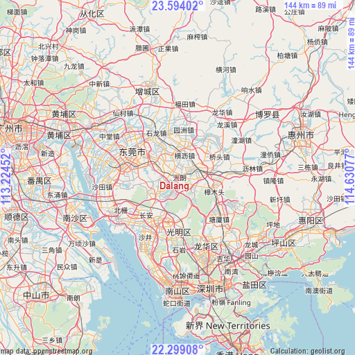
Dalang GPS coordinates[2]
22° 56' 53.16" North, 113° 55' 39.504" East
| Map corner | latitude | longitude |
|---|---|---|
| Upper-left | 23.59402°, | 113.22452° |
| Center: | 22.9481°, | 113.92764° |
| Lower-right: | 22.29908°, | 114.63077° |
| Map W x H: | 144×144 km | = 89.5×89.5mi |
| max Lat: | 53.31946° ⇑94.8% North |
| Dalang: | 22.9481° |
| min Lat: | ⇓5.2% South 18.22056° |
| min Long | Dalang | max Long |
| 75.07348° | 113.92764° | 134.28917° |
| W 48.2%⇐ | ⇒51.8% E |
Elevation
Elevation of Dalang is 18 m = 59 ft, and this is 466.8 m = 1531 ft below average elevation for this country.
| Max E: |
5622 m = 18445 ft | 83.9% |
| Avg. | 484.8 m = 1591 ft | |
| Dalang | 18 m = 59 ft | |
Min E: |
-3 m = -10 ft | 16.1% |
See also: China elevation on elevation.city.
Geographical zone
Dalang is located in North Torrid zone (between Equator and Tropic of Cancer). Distance of this Northern Tropic circle is 54.3 km =33.7 mi to North.| Distance of | km | miles | from Dalang |
|---|---|---|---|
| North Pole | 7455.5 | 4632.6 | to North |
| Arctic Circle | 4849.6 | 3013.4 | to North |
| Tropic Cancer | 54.3 | 33.7 | to North |
| Equator | 2551.6 | 1585.5 | to South |


Nearby cities:
15 places around Dalang: (largest is in red/bold)
• Changping
7.2 km =4.5 mi,  63°
63°
• Chashan
14.8 km =9.2 mi,  336°
336°
• Dongcheng
18.1 km =11.2 mi,  306°
306°
• Dongguan
19.9 km =12.4 mi,  292°
292°
• Dongkeng
4.7 km =2.9 mi,  17°
17°
• Gongming
18.5 km =11.5 mi,  194°
194°
• Guangming
19.6 km =12.2 mi,  179°
179°
• Hengli
9.4 km =5.8 mi, 16°
• Huangjiang
7.7 km =4.8 mi,  113°
113°
• Liaobu
7.4 km =4.6 mi,  320°
320°
• Qiaotou
18.9 km =11.7 mi, 63°
• Qishi
16.9 km =10.5 mi,  34°
34°
• Shipai
15.7 km =9.8 mi,  7°
7°
• Yuanzhou
19.6 km =12.2 mi, 6°
• Zhangmutou
16.1 km =10 mi, 113°
Sources, notices
• [Note1] Compared only with cities in China existing in our database
• [Src1] Map data: © OpenStreetMap contributors (CC-BY-SA)
• [Src2] Other city data from geonames.org with taken over terms of usage.
• [Src3] Geographical zone / Annual Mean Temperature by Robert A. Rohde @ Wikipedia
