Dongkeng geodata
Dongkeng (Guangdong) is a seat of a fourth-order administrative division; located in China in Asia/Shanghai (GMT+8) time zone. In our database, there are 1268 cities with bigger population. Compared to other cities in China, 94.5% of cities are located further ↑North; 51.7% of cities are located further →East and 89.9% of cities have higher elevation than Dongkeng. Note1


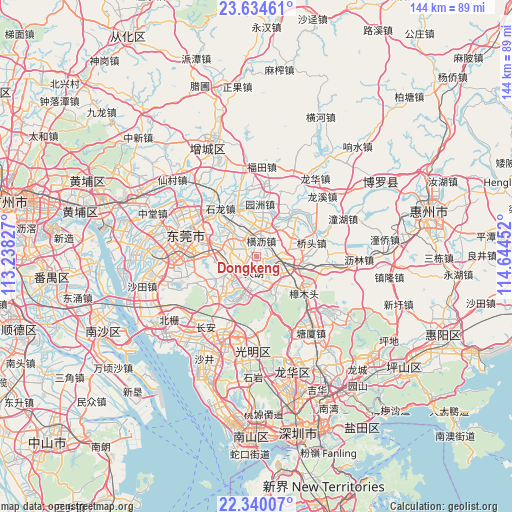
Dongkeng GPS coordinates[2]
22° 59' 20.004" North, 113° 56' 29.004" East
| Map corner | latitude | longitude |
|---|---|---|
| Upper-left | 23.63461°, | 113.23827° |
| Center: | 22.98889°, | 113.94139° |
| Lower-right: | 22.34007°, | 114.64452° |
| Map W x H: | 143.9×143.9 km | = 89.4×89.4mi |
| max Lat: | 53.31946° ⇑94.5% North |
| Dongkeng: | 22.98889° |
| min Lat: | ⇓5.5% South 18.22056° |
| min Long | Dongkeng | max Long |
| 75.07348° | 113.94139° | 134.28917° |
| W 48.3%⇐ | ⇒51.7% E |
Elevation
Elevation of Dongkeng is 10 m = 33 ft, and this is 474.8 m = 1558 ft below average elevation for this country.
| Max E: |
5622 m = 18445 ft | 89.9% |
| Avg. | 484.8 m = 1591 ft | |
| Dongkeng | 10 m = 33 ft | |
Min E: |
-3 m = -10 ft | 10.1% |
See also: China elevation on elevation.city.
Geographical zone
Dongkeng is located in North Torrid zone (between Equator and Tropic of Cancer). Distance of this Northern Tropic circle is 49.8 km =30.9 mi to North.| Distance of | km | miles | from Dongkeng |
|---|---|---|---|
| North Pole | 7450.9 | 4629.8 | to North |
| Arctic Circle | 4845 | 3010.5 | to North |
| Tropic Cancer | 49.8 | 30.9 | to North |
| Equator | 2556.1 | 1588.3 | to South |


Nearby cities:
15 places around Dongkeng: (largest is in red/bold)
• Changping
5.2 km =3.2 mi,  104°
104°
• Chashan
11.6 km =7.2 mi,  320°
320°
• Dalang
4.7 km =2.9 mi,  197°
197°
• Dongcheng
17.2 km =10.7 mi,  291°
291°
• Hengli
4.6 km =2.9 mi,  15°
15°
• Huangjiang
9.5 km =5.9 mi,  143°
143°
• Liaobu
6.2 km =3.9 mi,  281°
281°
• Qiaotou
15.9 km =9.9 mi,  75°
75°
• Qishi
12.4 km =7.7 mi,  41°
41°
• Shijie
19.3 km =12 mi,  307°
307°
• Shilong
17 km =10.6 mi,  325°
325°
• Shipai
11 km =6.8 mi,  3°
3°
• Shiwan
19.1 km =11.9 mi, 331°
• Yuanzhou
14.9 km =9.3 mi, 3°
• Zhangmutou
17.2 km =10.7 mi,  129°
129°
Sources, notices
• [Note1] Compared only with cities in China existing in our database
• [Src1] Map data: © OpenStreetMap contributors (CC-BY-SA)
• [Src2] Other city data from geonames.org with taken over terms of usage.
• [Src3] Geographical zone / Annual Mean Temperature by Robert A. Rohde @ Wikipedia
