Dafang geodata
Dafang (Guangdong) is a seat of a fourth-order administrative division; located in China in Asia/Shanghai (GMT+8) time zone. In our database, there are 1268 cities with bigger population. Compared to other cities in China, 94.6% of cities are located further ↑North; 64.7% of cities are located further →East and 59.5% of cities have lower elevation than Dafang. Note1


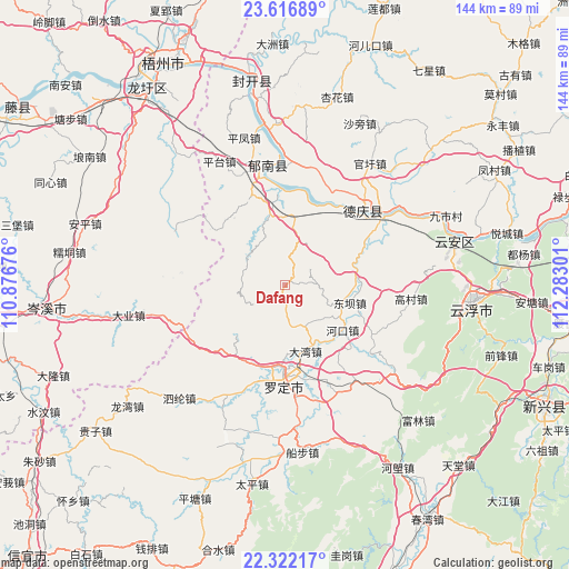
Dafang GPS coordinates[2]
22° 58' 15.888" North, 111° 34' 47.568" East
| Map corner | latitude | longitude |
|---|---|---|
| Upper-left | 23.61689°, | 110.87676° |
| Center: | 22.97108°, | 111.57988° |
| Lower-right: | 22.32217°, | 112.28301° |
| Map W x H: | 144×144 km | = 89.5×89.5mi |
| max Lat: | 53.31946° ⇑94.6% North |
| Dafang: | 22.97108° |
| min Lat: | ⇓5.4% South 18.22056° |
| min Long | Dafang | max Long |
| 75.07348° | 111.57988° | 134.28917° |
| W 35.3%⇐ | ⇒64.7% E |
Elevation
Elevation of Dafang is 253 m = 830 ft, and this is 231.8 m = 760 ft below average elevation for this country.
| Max E: |
5622 m = 18445 ft | 40.5% |
| Avg. | 484.8 m = 1591 ft | |
| Dafang | 253 m = 830 ft | |
Min E: |
-3 m = -10 ft | 59.5% |
See also: China elevation on elevation.city.
Geographical zone
Dafang is located in North Torrid zone (between Equator and Tropic of Cancer). Distance of this Northern Tropic circle is 51.8 km =32.2 mi to North.| Distance of | km | miles | from Dafang |
|---|---|---|---|
| North Pole | 7452.9 | 4631 | to North |
| Arctic Circle | 4847 | 3011.8 | to North |
| Tropic Cancer | 51.8 | 32.2 | to North |
| Equator | 2554.1 | 1587 | to South |


Nearby cities:
15 places around Dafang: (largest is in red/bold)
• Baozhu
16.1 km =10 mi,  11°
11°
• Chengdong
23.9 km =14.9 mi,  174°
174°
• Dawan
17.4 km =10.8 mi,  162°
162°
• Dongba
17.9 km =11.1 mi,  101°
101°
• Fucheng
21 km =13 mi,  182°
182°
• Guixu
23.6 km =14.7 mi,  328°
328°
• Hekou
18.1 km =11.2 mi,  128°
128°
• Jiancheng
18.9 km =11.7 mi,  347°
347°
• Liantan
15.3 km =9.5 mi,  105°
105°
• Lidong
8.4 km =5.2 mi,  86°
86°
• Luocheng
22.4 km =13.9 mi, 182°
• Qianguan
11.6 km =7.2 mi, 178°
• Shuangdong
19.8 km =12.3 mi, 175°
• Songgui
20.3 km =12.6 mi, 111°
• Tongmen
11.8 km =7.3 mi,  285°
285°
Sources, notices
• [Note1] Compared only with cities in China existing in our database
• [Src1] Map data: © OpenStreetMap contributors (CC-BY-SA)
• [Src2] Other city data from geonames.org with taken over terms of usage.
• [Src3] Geographical zone / Annual Mean Temperature by Robert A. Rohde @ Wikipedia
