Baozhu geodata
Baozhu (Guangdong) is a seat of a fourth-order administrative division; located in China in Asia/Shanghai (GMT+8) time zone. In our database, there are 1268 cities with bigger population. Compared to other cities in China, 93.9% of cities are located further ↑North; 64.5% of cities are located further →East and 65.6% of cities have higher elevation than Baozhu. Note1


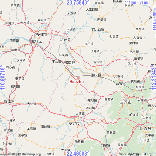
Baozhu GPS coordinates[2]
23° 6' 47.916" North, 111° 36' 37.08" East
| Map corner | latitude | longitude |
|---|---|---|
| Upper-left | 23.75843°, | 110.90718° |
| Center: | 23.11331°, | 111.6103° |
| Lower-right: | 22.46508°, | 112.31343° |
| Map W x H: | 143.8×143.8 km | = 89.4×89.4mi |
| max Lat: | 53.31946° ⇑93.9% North |
| Baozhu: | 23.11331° |
| min Lat: | ⇓6.1% South 18.22056° |
| min Long | Baozhu | max Long |
| 75.07348° | 111.6103° | 134.28917° |
| W 35.5%⇐ | ⇒64.5% E |
Elevation
Elevation of Baozhu is 70 m = 230 ft, and this is 414.8 m = 1361 ft below average elevation for this country.
| Max E: |
5622 m = 18445 ft | 65.6% |
| Avg. | 484.8 m = 1591 ft | |
| Baozhu | 70 m = 230 ft | |
Min E: |
-3 m = -10 ft | 34.4% |
See also: China elevation on elevation.city.
Geographical zone
Baozhu is located in North Torrid zone (between Equator and Tropic of Cancer). Distance of this Northern Tropic circle is 36 km =22.4 mi to North.| Distance of | km | miles | from Baozhu |
|---|---|---|---|
| North Pole | 7437.1 | 4621.2 | to North |
| Arctic Circle | 4831.2 | 3002 | to North |
| Tropic Cancer | 36 | 22.4 | to North |
| Equator | 2570 | 1596.9 | to South |


Nearby cities:
15 places around Baozhu: (largest is in red/bold)
• Changgang
18.5 km =11.5 mi,  350°
350°
• Dafang
16.1 km =10 mi,  191°
191°
• Decheng
17.7 km =11 mi,  79°
79°
• Dongba
24.1 km =15 mi,  143°
143°
• Ducheng
16.6 km =10.3 mi,  329°
329°
• Guanxu
24.6 km =15.3 mi,  49°
49°
• Guixu
16 km =9.9 mi,  285°
285°
• Huilong
11.6 km =7.2 mi,  44°
44°
• Jiancheng
7.8 km =4.8 mi, 289°
• Liantan
23 km =14.3 mi,  149°
149°
• Lidong
16.2 km =10.1 mi,  160°
160°
• Nanjiangkou
20.5 km =12.7 mi,  86°
86°
• Pingtai
25 km =15.5 mi,  307°
307°
• Tongmen
19.2 km =11.9 mi,  228°
228°
• Xinxu
16.8 km =10.4 mi,  68°
68°
Sources, notices
• [Note1] Compared only with cities in China existing in our database
• [Src1] Map data: © OpenStreetMap contributors (CC-BY-SA)
• [Src2] Other city data from geonames.org with taken over terms of usage.
• [Src3] Geographical zone / Annual Mean Temperature by Robert A. Rohde @ Wikipedia
