Liantan geodata
Liantan (Guangdong) is a seat of a fourth-order administrative division; located in China in Asia/Shanghai (GMT+8) time zone. In our database, there are 1268 cities with bigger population. Compared to other cities in China, 94.8% of cities are located further ↑North; 63.9% of cities are located further →East and 82.1% of cities have higher elevation than Liantan. Note1


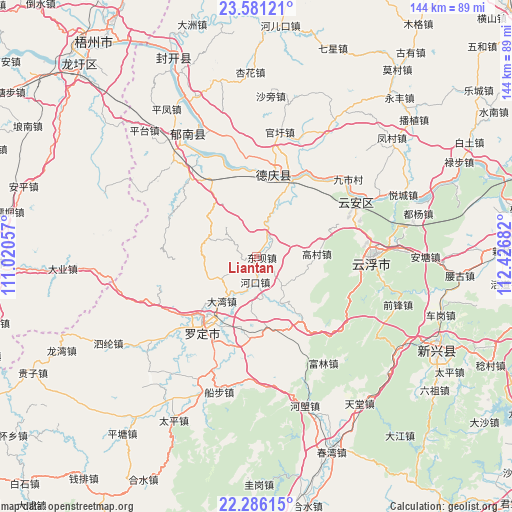
Liantan GPS coordinates[2]
22° 56' 6.828" North, 111° 43' 25.284" East
| Map corner | latitude | longitude |
|---|---|---|
| Upper-left | 23.58121°, | 111.02057° |
| Center: | 22.93523°, | 111.72369° |
| Lower-right: | 22.28615°, | 112.42682° |
| Map W x H: | 144×144 km | = 89.5×89.5mi |
| max Lat: | 53.31946° ⇑94.8% North |
| Liantan: | 22.93523° |
| min Lat: | ⇓5.2% South 18.22056° |
| min Long | Liantan | max Long |
| 75.07348° | 111.72369° | 134.28917° |
| W 36.1%⇐ | ⇒63.9% E |
Elevation
Elevation of Liantan is 22 m = 72 ft, and this is 462.8 m = 1518 ft below average elevation for this country.
| Max E: |
5622 m = 18445 ft | 82.1% |
| Avg. | 484.8 m = 1591 ft | |
| Liantan | 22 m = 72 ft | |
Min E: |
-3 m = -10 ft | 17.9% |
See also: China elevation on elevation.city.
Geographical zone
Liantan is located in North Torrid zone (between Equator and Tropic of Cancer). Distance of this Northern Tropic circle is 55.8 km =34.7 mi to North.| Distance of | km | miles | from Liantan |
|---|---|---|---|
| North Pole | 7456.9 | 4633.5 | to North |
| Arctic Circle | 4851 | 3014.3 | to North |
| Tropic Cancer | 55.8 | 34.7 | to North |
| Equator | 2550.2 | 1584.6 | to South |


Nearby cities:
15 places around Liantan: (largest is in red/bold)
• Baishi
14.7 km =9.1 mi,  150°
150°
• Baozhu
23 km =14.3 mi,  329°
329°
• Dafang
15.3 km =9.5 mi,  285°
285°
• Dawan
15.9 km =9.9 mi,  217°
217°
• Dongba
2.9 km =1.8 mi,  79°
79°
• Fucheng
23.1 km =14.4 mi, 222°
• Gaocun
16.9 km =10.5 mi,  86°
86°
• Hekou
7.2 km =4.5 mi,  184°
184°
• Huashi
19.2 km =11.9 mi,  191°
191°
• Lidong
7.7 km =4.8 mi,  305°
305°
• Nanjiangkou
23 km =14.3 mi,  22°
22°
• Pingtang
20.1 km =12.5 mi,  171°
171°
• Qianguan
16.3 km =10.1 mi,  242°
242°
• Shuangdong
20.5 km =12.7 mi, 219°
• Songgui
5.4 km =3.4 mi,  131°
131°
Sources, notices
• [Note1] Compared only with cities in China existing in our database
• [Src1] Map data: © OpenStreetMap contributors (CC-BY-SA)
• [Src2] Other city data from geonames.org with taken over terms of usage.
• [Src3] Geographical zone / Annual Mean Temperature by Robert A. Rohde @ Wikipedia
