Dabu geodata
Dabu (Guangdong) is a seat of a fourth-order administrative division; located in China in Asia/Shanghai (GMT+8) time zone. In our database, there are 1268 cities with bigger population. Compared to other cities in China, 88.3% of cities are located further ↑North; 56.7% of cities are located further →East and 78.6% of cities have lower elevation than Dabu. Note1


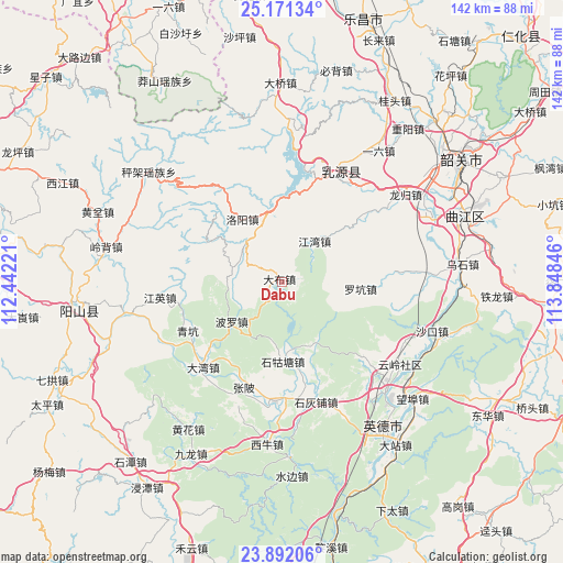
Dabu GPS coordinates[2]
24° 31' 59.988" North, 113° 8' 43.188" East
| Map corner | latitude | longitude |
|---|---|---|
| Upper-left | 25.17134°, | 112.44221° |
| Center: | 24.53333°, | 113.14533° |
| Lower-right: | 23.89206°, | 113.84846° |
| Map W x H: | 142.2×142.2 km | = 88.4×88.4mi |
| max Lat: | 53.31946° ⇑88.3% North |
| Dabu: | 24.53333° |
| min Lat: | ⇓11.7% South 18.22056° |
| min Long | Dabu | max Long |
| 75.07348° | 113.14533° | 134.28917° |
| W 43.3%⇐ | ⇒56.7% E |
Elevation
Elevation of Dabu is 638 m = 2093 ft, and this is 153.2 m = 503 ft above average elevation for this country.
| Max E: |
5622 m = 18445 ft | 21.4% |
| Dabu | 638 m 2093 ft | |
| Avg. | 484.8 m = 1591 ft | |
Min E: |
-3 m = -10 ft | 78.6% |
See also: China elevation on elevation.city.
Geographical zone
Dabu is located in North temperate zone (between Tropic of Cancer and the Arctic Circle). Distance of this Northern Tropic circle is 121.9 km =75.7 mi to South.| Distance of | km | miles | from Dabu |
|---|---|---|---|
| North Pole | 7279.2 | 4523.1 | to North |
| Arctic Circle | 4673.3 | 2903.9 | to North |
| Tropic Cancer | 121.9 | 75.7 | to South |
| Equator | 2727.9 | 1695 | to South |


Nearby cities:
15 places around Dabu: (largest is in red/bold)
• Boluo
16 km =9.9 mi,  236°
236°
• Dawan
30 km =18.6 mi,  224°
224°
• Dongping
23.8 km =14.8 mi,  10°
10°
• HanHuang
29.5 km =18.3 mi,  184°
184°
• Hengshitang
30.5 km =19 mi,  132°
132°
• Jiangwan
13.3 km =8.3 mi,  38°
38°
• Jiangying
31.2 km =19.4 mi,  262°
262°
• Luokeng
19.4 km =12.1 mi,  95°
95°
• Luoyang
19.1 km =11.9 mi,  327°
327°
• Qingkeng
27.3 km =17 mi, 242°
• Rucheng
30.1 km =18.7 mi,  24°
24°
• Shigutang
19.1 km =11.9 mi, 179°
• Shihuipu
30.9 km =19.2 mi,  163°
163°
• Yunling
36.2 km =22.5 mi,  124°
124°
• Zhangbei
28.4 km =17.6 mi,  199°
199°
Sources, notices
• [Note1] Compared only with cities in China existing in our database
• [Src1] Map data: © OpenStreetMap contributors (CC-BY-SA)
• [Src2] Other city data from geonames.org with taken over terms of usage.
• [Src3] Geographical zone / Annual Mean Temperature by Robert A. Rohde @ Wikipedia
