Luoyang geodata
Luoyang (Guangdong) is a seat of a fourth-order administrative division; located in China in Asia/Shanghai (GMT+8) time zone. In our database, there are 1268 cities with bigger population. Compared to other cities in China, 87.7% of cities are located further ↑North; 57.3% of cities are located further →East and 79.9% of cities have lower elevation than Luoyang. Note1


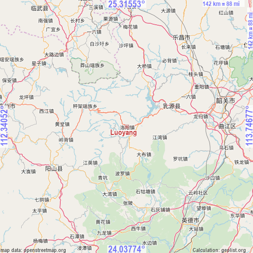
Luoyang GPS coordinates[2]
24° 40' 41.772" North, 113° 2' 37.104" East
| Map corner | latitude | longitude |
|---|---|---|
| Upper-left | 25.31553°, | 112.34052° |
| Center: | 24.67827°, | 113.04364° |
| Lower-right: | 24.03774°, | 113.74677° |
| Map W x H: | 142.1×142.1 km | = 88.3×88.3mi |
| max Lat: | 53.31946° ⇑87.7% North |
| Luoyang: | 24.67827° |
| min Lat: | ⇓12.3% South 18.22056° |
| min Long | Luoyang | max Long |
| 75.07348° | 113.04364° | 134.28917° |
| W 42.7%⇐ | ⇒57.3% E |
Elevation
Elevation of Luoyang is 688 m = 2257 ft, and this is 203.2 m = 667 ft above average elevation for this country.
| Max E: |
5622 m = 18445 ft | 20.1% |
| Luoyang | 688 m 2257 ft | |
| Avg. | 484.8 m = 1591 ft | |
Min E: |
-3 m = -10 ft | 79.9% |
See also: China elevation on elevation.city.
Geographical zone
Luoyang is located in North temperate zone (between Tropic of Cancer and the Arctic Circle). Distance of this Northern Tropic circle is 138 km =85.7 mi to South.| Distance of | km | miles | from Luoyang |
|---|---|---|---|
| North Pole | 7263.1 | 4513.1 | to North |
| Arctic Circle | 4657.2 | 2893.8 | to North |
| Tropic Cancer | 138 | 85.7 | to South |
| Equator | 2744 | 1705 | to South |


Nearby cities:
15 places around Luoyang: (largest is in red/bold)
• Boluo
25.1 km =15.6 mi,  187°
187°
• Chengjia
26.7 km =16.6 mi,  292°
292°
• Dabu
19.1 km =11.9 mi,  147°
147°
• Daqiao
35.1 km =21.8 mi,  14°
14°
• Dawan
39 km =24.2 mi,  196°
196°
• Dongping
16.3 km =10.1 mi,  63°
63°
• Huangben
36.3 km =22.6 mi,  272°
272°
• Jiangwan
19.5 km =12.1 mi,  107°
107°
• Jiangying
28.7 km =17.8 mi,  225°
225°
• Lingbei
35.1 km =21.8 mi,  258°
258°
• Luokeng
34.6 km =21.5 mi,  121°
121°
• Qingkeng
31.9 km =19.8 mi,  205°
205°
• Qinglian
37.6 km =23.4 mi, 230°
• Rucheng
25.5 km =15.8 mi, 63°
• Shigutang
36.7 km =22.8 mi,  163°
163°
Sources, notices
• [Note1] Compared only with cities in China existing in our database
• [Src1] Map data: © OpenStreetMap contributors (CC-BY-SA)
• [Src2] Other city data from geonames.org with taken over terms of usage.
• [Src3] Geographical zone / Annual Mean Temperature by Robert A. Rohde @ Wikipedia
