Dongping geodata
Dongping (Guangdong) is a seat of a fourth-order administrative division; located in China in Asia/Shanghai (GMT+8) time zone. In our database, there are 1268 cities with bigger population. Compared to other cities in China, 87.4% of cities are located further ↑North; 56.4% of cities are located further →East and 73.4% of cities have lower elevation than Dongping. Note1


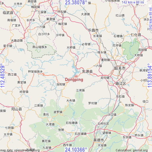
Dongping GPS coordinates[2]
24° 44' 37.896" North, 113° 11' 18.276" East
| Map corner | latitude | longitude |
|---|---|---|
| Upper-left | 25.38078°, | 112.48529° |
| Center: | 24.74386°, | 113.18841° |
| Lower-right: | 24.10366°, | 113.89154° |
| Map W x H: | 142×142 km | = 88.2×88.2mi |
| max Lat: | 53.31946° ⇑87.4% North |
| Dongping: | 24.74386° |
| min Lat: | ⇓12.6% South 18.22056° |
| min Long | Dongping | max Long |
| 75.07348° | 113.18841° | 134.28917° |
| W 43.6%⇐ | ⇒56.4% E |
Elevation
Elevation of Dongping is 483 m = 1585 ft, and this is 1.8 m = 6 ft below average elevation for this country.
| Max E: |
5622 m = 18445 ft | 26.6% |
| Avg. | 484.8 m = 1591 ft | |
| Dongping | 483 m = 1585 ft | |
Min E: |
-3 m = -10 ft | 73.4% |
See also: China elevation on elevation.city.
Geographical zone
Dongping is located in North temperate zone (between Tropic of Cancer and the Arctic Circle). Distance of this Northern Tropic circle is 145.3 km =90.3 mi to South.| Distance of | km | miles | from Dongping |
|---|---|---|---|
| North Pole | 7255.8 | 4508.5 | to North |
| Arctic Circle | 4649.9 | 2889.3 | to North |
| Tropic Cancer | 145.3 | 90.3 | to South |
| Equator | 2751.3 | 1709.6 | to South |


Nearby cities:
15 places around Dongping: (largest is in red/bold)
• Baitu
33.6 km =20.9 mi,  101°
101°
• Bibei
30.9 km =19.2 mi,  17°
17°
• Boluo
36.8 km =22.9 mi,  208°
208°
• Dabu
23.8 km =14.8 mi,  190°
190°
• Daqiao
27.2 km =16.9 mi,  348°
348°
• Guitou
31.2 km =19.4 mi,  47°
47°
• Jiangwan
13.6 km =8.5 mi,  162°
162°
• Longgui
26.3 km =16.3 mi,  92°
92°
• Luokeng
29.3 km =18.2 mi,  149°
149°
• Luoyang
16.3 km =10.1 mi,  243°
243°
• Rucheng
9.2 km =5.7 mi,  64°
64°
• Xilian
35.1 km =21.8 mi, 86°
• Yiliu
24.1 km =15 mi, 64°
• Youxi
29.4 km =18.3 mi,  36°
36°
• Zhongyang
31.5 km =19.6 mi, 60°
Sources, notices
• [Note1] Compared only with cities in China existing in our database
• [Src1] Map data: © OpenStreetMap contributors (CC-BY-SA)
• [Src2] Other city data from geonames.org with taken over terms of usage.
• [Src3] Geographical zone / Annual Mean Temperature by Robert A. Rohde @ Wikipedia
