Cunliji geodata
Cunliji (Shandong) is a seat of a fourth-order administrative division; located in China in Asia/Shanghai (GMT+8) time zone. In our database, there are 1268 cities with bigger population. Compared to other cities in China, 80.3% of cities are located further ↓South; 86.7% of cities are located further ←West and 58.4% of cities have higher elevation than Cunliji. Note1


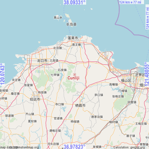
Cunliji GPS coordinates[2]
37° 32' 16.26" North, 120° 46' 38.712" East
| Map corner | latitude | longitude |
|---|---|---|
| Upper-left | 38.09331°, | 120.0743° |
| Center: | 37.53785°, | 120.77742° |
| Lower-right: | 36.97823°, | 121.48055° |
| Map W x H: | 124×124 km | = 77.1×77.1mi |
| max Lat: | 53.31946° ⇑19.7% North |
| Cunliji: | 37.53785° |
| min Lat: | ⇓80.3% South 18.22056° |
| min Long | Cunliji | max Long |
| 75.07348° | 120.77742° | 134.28917° |
| W 86.7%⇐ | ⇒13.3% E |
Elevation
Elevation of Cunliji is 109 m = 358 ft, and this is 375.8 m = 1233 ft below average elevation for this country.
| Max E: |
5622 m = 18445 ft | 58.4% |
| Avg. | 484.8 m = 1591 ft | |
| Cunliji | 109 m = 358 ft | |
Min E: |
-3 m = -10 ft | 41.6% |
See also: China elevation on elevation.city.
Geographical zone
Cunliji is located in North temperate zone (between Tropic of Cancer and the Arctic Circle). Distance of this Northern Tropic circle is 1567.9 km =974.2 mi to South.| Distance of | km | miles | from Cunliji |
|---|---|---|---|
| North Pole | 5833.2 | 3624.6 | to North |
| Arctic Circle | 3227.4 | 2005.4 | to North |
| Tropic Cancer | 1567.9 | 974.2 | to South |
| Equator | 4173.8 | 2593.5 | to South |


Nearby cities:
15 places around Cunliji: (largest is in red/bold)
• Chaoshui
24.2 km =15 mi,  44°
44°
• Daliuhang
25.1 km =15.6 mi,  71°
71°
• Daxindian
11.4 km =7.1 mi, 35°
• Fushan
24.8 km =15.4 mi,  231°
231°
• Langao
20.5 km =12.7 mi,  304°
304°
• Nanwang
25.1 km =15.6 mi,  3°
3°
• Qijia
16.3 km =10.1 mi,  269°
269°
• Shiliang
11.1 km =6.9 mi,  293°
293°
• Songshan
16 km =9.9 mi,  152°
152°
• Sujiadian
15.8 km =9.8 mi,  214°
214°
• Xiadingjia
24.9 km =15.5 mi, 270°
• Xiaomenjia
10.1 km =6.3 mi,  9°
9°
• Xicheng
24.9 km =15.5 mi,  185°
185°
• Zangjiazhuang
20 km =12.4 mi,  113°
113°
• Zhuyouguan
24.1 km =15 mi,  314°
314°
Sources, notices
• [Note1] Compared only with cities in China existing in our database
• [Src1] Map data: © OpenStreetMap contributors (CC-BY-SA)
• [Src2] Other city data from geonames.org with taken over terms of usage.
• [Src3] Geographical zone / Annual Mean Temperature by Robert A. Rohde @ Wikipedia
