Songshan geodata
Songshan (Shandong) is a seat of a fourth-order administrative division; located in China in Asia/Shanghai (GMT+8) time zone. In our database, there are 1268 cities with bigger population. Compared to other cities in China, 80.1% of cities are located further ↓South; 87.1% of cities are located further ←West and 61.1% of cities have higher elevation than Songshan. Note1


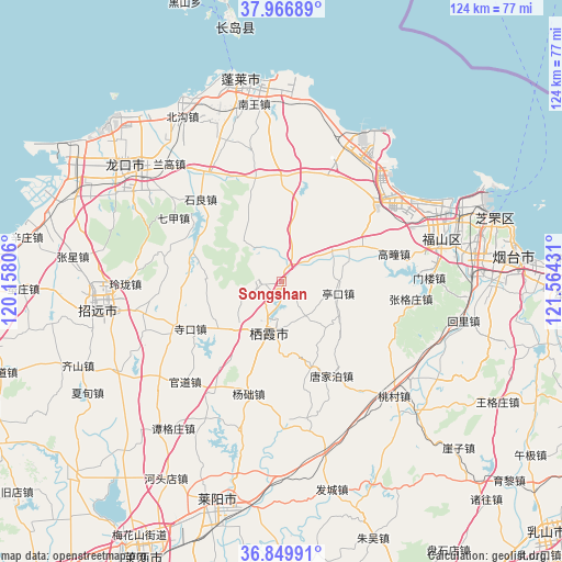
Songshan GPS coordinates[2]
37° 24' 37.728" North, 120° 51' 40.248" East
| Map corner | latitude | longitude |
|---|---|---|
| Upper-left | 37.96689°, | 120.15806° |
| Center: | 37.41048°, | 120.86118° |
| Lower-right: | 36.84991°, | 121.56431° |
| Map W x H: | 124.2×124.2 km | = 77.2×77.2mi |
| max Lat: | 53.31946° ⇑19.9% North |
| Songshan: | 37.41048° |
| min Lat: | ⇓80.1% South 18.22056° |
| min Long | Songshan | max Long |
| 75.07348° | 120.86118° | 134.28917° |
| W 87.1%⇐ | ⇒12.9% E |
Elevation
Elevation of Songshan is 92 m = 302 ft, and this is 392.8 m = 1289 ft below average elevation for this country.
| Max E: |
5622 m = 18445 ft | 61.1% |
| Avg. | 484.8 m = 1591 ft | |
| Songshan | 92 m = 302 ft | |
Min E: |
-3 m = -10 ft | 38.9% |
See also: China elevation on elevation.city.
Geographical zone
Songshan is located in North temperate zone (between Tropic of Cancer and the Arctic Circle). Distance of this Northern Tropic circle is 1553.7 km =965.4 mi to South.| Distance of | km | miles | from Songshan |
|---|---|---|---|
| North Pole | 5847.4 | 3633.4 | to North |
| Arctic Circle | 3241.5 | 2014.2 | to North |
| Tropic Cancer | 1553.7 | 965.4 | to South |
| Equator | 4159.7 | 2584.7 | to South |


Nearby cities:
15 places around Songshan: (largest is in red/bold)
• Cunliji
16 km =9.9 mi,  332°
332°
• Daliuhang
27.5 km =17.1 mi,  36°
36°
• Daxindian
23.4 km =14.5 mi,  358°
358°
• Fushan
26.8 km =16.7 mi,  267°
267°
• Gaotuan
25.6 km =15.9 mi,  76°
76°
• Qijia
27.6 km =17.1 mi,  300°
300°
• Shiliang
25.6 km =15.9 mi,  316°
316°
• Sikou
22.5 km =14 mi,  242°
242°
• Sujiadian
16.4 km =10.2 mi, 274°
• Tangjiapo
23.5 km =14.6 mi,  151°
151°
• Xiaomenjia
24.8 km =15.4 mi,  346°
346°
• Xicheng
14.3 km =8.9 mi,  221°
221°
• Yangchu
25.4 km =15.8 mi,  196°
196°
• Zangjiazhuang
12.6 km =7.8 mi,  60°
60°
• Zhuangyuan
12 km =7.5 mi,  194°
194°
Sources, notices
• [Note1] Compared only with cities in China existing in our database
• [Src1] Map data: © OpenStreetMap contributors (CC-BY-SA)
• [Src2] Other city data from geonames.org with taken over terms of usage.
• [Src3] Geographical zone / Annual Mean Temperature by Robert A. Rohde @ Wikipedia
