Chixi geodata
Chixi (Fujian) is a populated place; located in China in Asia/Shanghai (GMT+8) time zone. With population of 3,810 people, there are 902 cities with bigger population in this country. Compared to other cities in China, 79% of cities are located further ↑North; 78.7% of cities are located further ←West and 56.3% of cities have higher elevation than Chixi. Note1


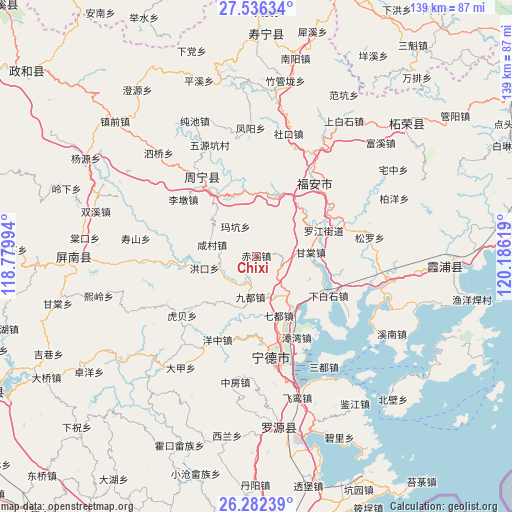
Chixi GPS coordinates[2]
26° 54' 39.996" North, 119° 28' 59.016" East
| Map corner | latitude | longitude |
|---|---|---|
| Upper-left | 27.53634°, | 118.77994° |
| Center: | 26.91111°, | 119.48306° |
| Lower-right: | 26.28239°, | 120.18619° |
| Map W x H: | 139.4×139.4 km | = 86.6×86.6mi |
| max Lat: | 53.31946° ⇑79% North |
| Chixi: | 26.91111° |
| min Lat: | ⇓21% South 18.22056° |
| min Long | Chixi | max Long |
| 75.07348° | 119.48306° | 134.28917° |
| W 78.7%⇐ | ⇒21.3% E |
Elevation
Elevation of Chixi is 122 m = 400 ft, and this is 362.8 m = 1190 ft below average elevation for this country.
| Max E: |
5622 m = 18445 ft | 56.3% |
| Avg. | 484.8 m = 1591 ft | |
| Chixi | 122 m = 400 ft | |
Min E: |
-3 m = -10 ft | 43.7% |
See also: China elevation on elevation.city.
Geographical zone
Chixi is located in North temperate zone (between Tropic of Cancer and the Arctic Circle). Distance of this Northern Tropic circle is 386.3 km =240 mi to South.| Distance of | km | miles | from Chixi |
|---|---|---|---|
| North Pole | 7014.8 | 4358.8 | to North |
| Arctic Circle | 4408.9 | 2739.6 | to North |
| Tropic Cancer | 386.3 | 240 | to South |
| Equator | 2992.2 | 1859.3 | to South |


Nearby cities:
15 places around Chixi: (largest is in red/bold)
• Badu
13.8 km =8.6 mi,  144°
144°
• Dingtoucun
19.4 km =12.1 mi,  114°
114°
• Fu’an
23.9 km =14.9 mi,  44°
44°
• Gantang
14.9 km =9.3 mi,  86°
86°
• Huotong
9.4 km =5.8 mi,  223°
223°
• Kangcuo
16.5 km =10.3 mi,  17°
17°
• Muyang
17.1 km =10.6 mi,  12°
12°
• Muyun
17.7 km =11 mi, 19°
• Qibu
23.1 km =14.4 mi,  322°
322°
• Qidu
17.4 km =10.8 mi,  158°
158°
• Xiabaishi
22.2 km =13.8 mi,  118°
118°
• Xiancun
12.6 km =7.8 mi,  284°
284°
• Xibing
25.2 km =15.7 mi,  71°
71°
• Xitan
17.3 km =10.7 mi,  50°
50°
• Zhangwan
24.7 km =15.3 mi,  154°
154°
Sources, notices
• [Note1] Compared only with cities in China existing in our database
• [Src1] Map data: © OpenStreetMap contributors (CC-BY-SA)
• [Src2] Other city data from geonames.org with taken over terms of usage.
• [Src3] Geographical zone / Annual Mean Temperature by Robert A. Rohde @ Wikipedia
