Xiabaishi geodata
Xiabaishi (Fujian) is a populated place; located in China in Asia/Shanghai (GMT+8) time zone. With population of 8,320 people, there are 825 cities with bigger population in this country. Compared to other cities in China, 79.3% of cities are located further ↑North; 79.9% of cities are located further ←West and 72.7% of cities have higher elevation than Xiabaishi. Note1


Xiabaishi GPS coordinates[2]
26° 48' 55.008" North, 119° 40' 45.012" East
| Map corner | latitude | longitude |
|---|---|---|
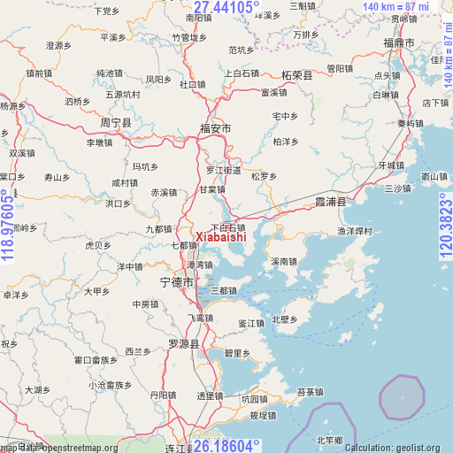
| Upper-left | 27.44105°, | 118.97605° |
| Center: | 26.81528°, | 119.67917° |
| Lower-right: | 26.18604°, | 120.3823° |
| Map W x H: | 139.5×139.5 km | = 86.7×86.7mi |
| max Lat: | 53.31946° ⇑79.3% North |
| Xiabaishi: | 26.81528° |
| min Lat: | ⇓20.7% South 18.22056° |
| min Long | Xiabaishi | max Long |
| 75.07348° | 119.67917° | 134.28917° |
| W 79.9%⇐ | ⇒20.1% E |
Elevation
Elevation of Xiabaishi is 43 m = 141 ft, and this is 441.8 m = 1449 ft below average elevation for this country.
| Max E: |
5622 m = 18445 ft | 72.7% |
| Avg. | 484.8 m = 1591 ft | |
| Xiabaishi | 43 m = 141 ft | |
Min E: |
-3 m = -10 ft | 27.3% |
See also: China elevation on elevation.city.
Geographical zone
Xiabaishi is located in North temperate zone (between Tropic of Cancer and the Arctic Circle). Distance of this Northern Tropic circle is 375.7 km =233.4 mi to South.| Distance of | km | miles | from Xiabaishi |
|---|---|---|---|
| North Pole | 7025.5 | 4365.4 | to North |
| Arctic Circle | 4419.6 | 2746.2 | to North |
| Tropic Cancer | 375.7 | 233.4 | to South |
| Equator | 2981.6 | 1852.7 | to South |


Nearby cities:
15 places around Xiabaishi: (largest is in red/bold)
• Badu
11.4 km =7.1 mi,  267°
267°
• Chixi
22.2 km =13.8 mi,  298°
298°
• Chongru
28.7 km =17.8 mi,  58°
58°
• Dingtoucun
3.3 km =2.1 mi,  326°
326°
• Fu’an
27.7 km =17.2 mi,  354°
354°
• Gantang
12.5 km =7.8 mi,  338°
338°
• Huotong
26.2 km =16.3 mi,  278°
278°
• Ningde
23.1 km =14.4 mi,  222°
222°
• Qidu
14.2 km =8.8 mi,  246°
246°
• Songqi
19.6 km =12.2 mi,  182°
182°
• Xibing
19 km =11.8 mi,  13°
13°
• Xinan
20.5 km =12.7 mi,  121°
121°
• Xitan
22.5 km =14 mi, 344°
• Yantian
18.2 km =11.3 mi,  76°
76°
• Zhangwan
14.4 km =8.9 mi, 216°
Sources, notices
• [Note1] Compared only with cities in China existing in our database
• [Src1] Map data: © OpenStreetMap contributors (CC-BY-SA)
• [Src2] Other city data from geonames.org with taken over terms of usage.
• [Src3] Geographical zone / Annual Mean Temperature by Robert A. Rohde @ Wikipedia
