Chenying geodata
Chenying (Jiangxi) is a seat of a third-order administrative division; located in China in Asia/Shanghai (GMT+8) time zone. In our database, there are 1268 cities with bigger population. Compared to other cities in China, 68% of cities are located further ↑North; 66.3% of cities are located further ←West and 69.7% of cities have higher elevation than Chenying. Note1


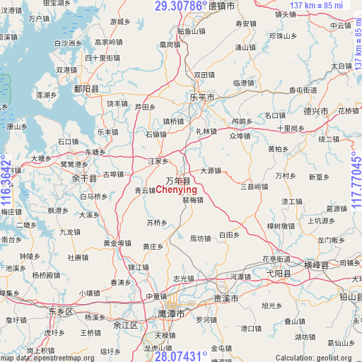
Chenying GPS coordinates[2]
28° 41' 34.44" North, 117° 4' 2.352" East
| Map corner | latitude | longitude |
|---|---|---|
| Upper-left | 29.30786°, | 116.3642° |
| Center: | 28.6929°, | 117.06732° |
| Lower-right: | 28.07431°, | 117.77045° |
| Map W x H: | 137.2×137.2 km | = 85.3×85.3mi |
| max Lat: | 53.31946° ⇑68% North |
| Chenying: | 28.6929° |
| min Lat: | ⇓32% South 18.22056° |
| min Long | Chenying | max Long |
| 75.07348° | 117.06732° | 134.28917° |
| W 66.3%⇐ | ⇒33.7% E |
Elevation
Elevation of Chenying is 53 m = 174 ft, and this is 431.8 m = 1417 ft below average elevation for this country.
| Max E: |
5622 m = 18445 ft | 69.7% |
| Avg. | 484.8 m = 1591 ft | |
| Chenying | 53 m = 174 ft | |
Min E: |
-3 m = -10 ft | 30.3% |
See also: China elevation on elevation.city.
Geographical zone
Chenying is located in North temperate zone (between Tropic of Cancer and the Arctic Circle). Distance of this Northern Tropic circle is 584.4 km =363.1 mi to South.| Distance of | km | miles | from Chenying |
|---|---|---|---|
| North Pole | 6816.7 | 4235.7 | to North |
| Arctic Circle | 4210.8 | 2616.5 | to North |
| Tropic Cancer | 584.4 | 363.1 | to South |
| Equator | 3190.4 | 1982.4 | to South |


Nearby cities:
15 places around Chenying: (largest is in red/bold)
• Dahuang
16.5 km =10.3 mi,  307°
307°
• Dayuan
11.9 km =7.4 mi,  64°
64°
• Huaqiao
19.8 km =12.3 mi,  186°
186°
• Lilin
21.2 km =13.2 mi,  26°
26°
• Peimei
6.9 km =4.3 mi,  149°
149°
• Qibu
20.1 km =12.5 mi,  279°
279°
• Qingyun
14.3 km =8.9 mi,  256°
256°
• Shangfang
2.6 km =1.6 mi,  232°
232°
• Shizhen
20.5 km =12.7 mi,  331°
331°
• Suqiaoxiang
18 km =11.2 mi, 228°
• Wangjia
12.7 km =7.9 mi, 278°
• Zhenqiao
23 km =14.3 mi,  352°
352°
• Zhoufang
20.6 km =12.8 mi, 151°
• Zhushan
1.4 km =0.9 mi, 354°
• Zhutian
7.4 km =4.6 mi,  10°
10°
Sources, notices
• [Note1] Compared only with cities in China existing in our database
• [Src1] Map data: © OpenStreetMap contributors (CC-BY-SA)
• [Src2] Other city data from geonames.org with taken over terms of usage.
• [Src3] Geographical zone / Annual Mean Temperature by Robert A. Rohde @ Wikipedia
