Shangfang geodata
Shangfang (Jiangxi) is a seat of a fourth-order administrative division; located in China in Asia/Shanghai (GMT+8) time zone. In our database, there are 1268 cities with bigger population. Compared to other cities in China, 68.2% of cities are located further ↑North; 66.2% of cities are located further ←West and 70% of cities have higher elevation than Shangfang. Note1


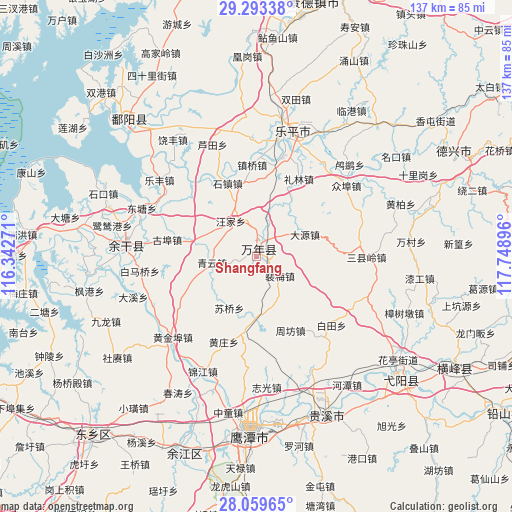
Shangfang GPS coordinates[2]
28° 40' 41.988" North, 117° 2' 44.988" East
| Map corner | latitude | longitude |
|---|---|---|
| Upper-left | 29.29338°, | 116.34271° |
| Center: | 28.67833°, | 117.04583° |
| Lower-right: | 28.05965°, | 117.74896° |
| Map W x H: | 137.2×137.2 km | = 85.3×85.3mi |
| max Lat: | 53.31946° ⇑68.2% North |
| Shangfang: | 28.67833° |
| min Lat: | ⇓31.8% South 18.22056° |
| min Long | Shangfang | max Long |
| 75.07348° | 117.04583° | 134.28917° |
| W 66.2%⇐ | ⇒33.8% E |
Elevation
Elevation of Shangfang is 52 m = 171 ft, and this is 432.8 m = 1420 ft below average elevation for this country.
| Max E: |
5622 m = 18445 ft | 70% |
| Avg. | 484.8 m = 1591 ft | |
| Shangfang | 52 m = 171 ft | |
Min E: |
-3 m = -10 ft | 30% |
See also: China elevation on elevation.city.
Geographical zone
Shangfang is located in North temperate zone (between Tropic of Cancer and the Arctic Circle). Distance of this Northern Tropic circle is 582.8 km =362.1 mi to South.| Distance of | km | miles | from Shangfang |
|---|---|---|---|
| North Pole | 6818.3 | 4236.7 | to North |
| Arctic Circle | 4212.4 | 2617.5 | to North |
| Tropic Cancer | 582.8 | 362.1 | to South |
| Equator | 3188.7 | 1981.4 | to South |


Nearby cities:
15 places around Shangfang: (largest is in red/bold)
• Chenying
2.6 km =1.6 mi,  52°
52°
• Dahuang
16 km =9.9 mi,  316°
316°
• Dayuan
14.5 km =9 mi,  62°
62°
• Huaqiao
18 km =11.2 mi,  180°
180°
• Lilin
23.6 km =14.7 mi,  29°
29°
• Peimei
7.1 km =4.4 mi,  127°
127°
• Qibu
18.4 km =11.4 mi,  285°
285°
• Qingyun
12 km =7.5 mi,  261°
261°
• Shizhen
21 km =13 mi,  338°
338°
• Suqiaoxiang
15.3 km =9.5 mi,  227°
227°
• Wangjia
11 km =6.8 mi, 288°
• Wuleixiang
22.7 km =14.1 mi,  241°
241°
• Zhoufang
20.3 km =12.6 mi,  144°
144°
• Zhushan
3.6 km =2.2 mi, 32°
• Zhutian
9.6 km =6 mi,  21°
21°
Sources, notices
• [Note1] Compared only with cities in China existing in our database
• [Src1] Map data: © OpenStreetMap contributors (CC-BY-SA)
• [Src2] Other city data from geonames.org with taken over terms of usage.
• [Src3] Geographical zone / Annual Mean Temperature by Robert A. Rohde @ Wikipedia
