Chengfeng geodata
Chengfeng (Jiangxi) is a seat of a fourth-order administrative division; located in China in Asia/Shanghai (GMT+8) time zone. In our database, there are 1268 cities with bigger population. Compared to other cities in China, 66% of cities are located further ↑North; 58.2% of cities are located further ←West and 82.1% of cities have higher elevation than Chengfeng. Note1


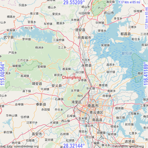
Chengfeng GPS coordinates[2]
28° 56' 18.924" North, 115° 42' 31.536" East
| Map corner | latitude | longitude |
|---|---|---|
| Upper-left | 29.55209°, | 115.00564° |
| Center: | 28.93859°, | 115.70876° |
| Lower-right: | 28.32144°, | 116.41189° |
| Map W x H: | 136.8×136.8 km | = 85×85mi |
| max Lat: | 53.31946° ⇑66% North |
| Chengfeng: | 28.93859° |
| min Lat: | ⇓34% South 18.22056° |
| min Long | Chengfeng | max Long |
| 75.07348° | 115.70876° | 134.28917° |
| W 58.2%⇐ | ⇒41.8% E |
Elevation
Elevation of Chengfeng is 22 m = 72 ft, and this is 462.8 m = 1518 ft below average elevation for this country.
| Max E: |
5622 m = 18445 ft | 82.1% |
| Avg. | 484.8 m = 1591 ft | |
| Chengfeng | 22 m = 72 ft | |
Min E: |
-3 m = -10 ft | 17.9% |
See also: China elevation on elevation.city.
Geographical zone
Chengfeng is located in North temperate zone (between Tropic of Cancer and the Arctic Circle). Distance of this Northern Tropic circle is 611.8 km =380.2 mi to South.| Distance of | km | miles | from Chengfeng |
|---|---|---|---|
| North Pole | 6789.4 | 4218.7 | to North |
| Arctic Circle | 4183.5 | 2599.5 | to North |
| Tropic Cancer | 611.8 | 380.2 | to South |
| Equator | 3217.7 | 1999.4 | to South |


Nearby cities:
15 places around Chengfeng: (largest is in red/bold)
• Aicheng
17.4 km =10.8 mi,  17°
17°
• Changjun
8.1 km =5 mi,  176°
176°
• Dongyangzhen
10.3 km =6.4 mi,  222°
222°
• Jiuhe
16.8 km =10.4 mi,  39°
39°
• Lixin
9.8 km =6.1 mi, 18°
• Luoting
9.3 km =5.8 mi,  125°
125°
• Makou
5.5 km =3.4 mi,  68°
68°
• Meiling
16.7 km =10.4 mi,  167°
167°
• Taiping
14.9 km =9.3 mi, 178°
• Tanxi
8.8 km =5.5 mi,  305°
305°
• Tubu
15.6 km =9.7 mi, 40°
• Wanbu
10.5 km =6.5 mi,  211°
211°
• Xinminxiang
14.7 km =9.1 mi,  267°
267°
• Xixia
15.8 km =9.8 mi,  124°
124°
• Yangsi
7.6 km =4.7 mi, 36°
Sources, notices
• [Note1] Compared only with cities in China existing in our database
• [Src1] Map data: © OpenStreetMap contributors (CC-BY-SA)
• [Src2] Other city data from geonames.org with taken over terms of usage.
• [Src3] Geographical zone / Annual Mean Temperature by Robert A. Rohde @ Wikipedia
