Dongyangzhen geodata
Dongyangzhen (Jiangxi) is a seat of a fourth-order administrative division; located in China in Asia/Shanghai (GMT+8) time zone. In our database, there are 1268 cities with bigger population. Compared to other cities in China, 66.6% of cities are located further ↑North; 57.8% of cities are located further ←West and 74.8% of cities have higher elevation than Dongyangzhen. Note1


Dongyangzhen GPS coordinates[2]
28° 52' 14.088" North, 115° 38' 12.624" East
| Map corner | latitude | longitude |
|---|---|---|
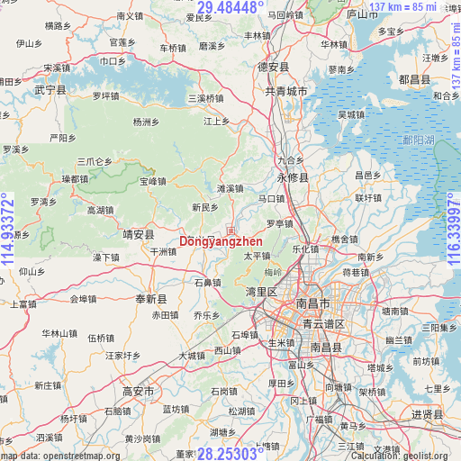
| Upper-left | 29.48448°, | 114.93372° |
| Center: | 28.87058°, | 115.63684° |
| Lower-right: | 28.25303°, | 116.33997° |
| Map W x H: | 136.9×136.9 km | = 85.1×85.1mi |
| max Lat: | 53.31946° ⇑66.6% North |
| Dongyangzhen: | 28.87058° |
| min Lat: | ⇓33.4% South 18.22056° |
| min Long | Dongyangzhen | max Long |
| 75.07348° | 115.63684° | 134.28917° |
| W 57.8%⇐ | ⇒42.2% E |
Elevation
Elevation of Dongyangzhen is 37 m = 121 ft, and this is 447.8 m = 1469 ft below average elevation for this country.
| Max E: |
5622 m = 18445 ft | 74.8% |
| Avg. | 484.8 m = 1591 ft | |
| Dongyangzhen | 37 m = 121 ft | |
Min E: |
-3 m = -10 ft | 25.2% |
See also: China elevation on elevation.city.
Geographical zone
Dongyangzhen is located in North temperate zone (between Tropic of Cancer and the Arctic Circle). Distance of this Northern Tropic circle is 604.2 km =375.4 mi to South.| Distance of | km | miles | from Dongyangzhen |
|---|---|---|---|
| North Pole | 6797 | 4223.5 | to North |
| Arctic Circle | 4191.1 | 2604.2 | to North |
| Tropic Cancer | 604.2 | 375.4 | to South |
| Equator | 3210.1 | 1994.7 | to South |


Nearby cities:
15 places around Dongyangzhen: (largest is in red/bold)
• Changbu
8.5 km =5.3 mi,  188°
188°
• Changjun
7.5 km =4.7 mi,  93°
93°
• Chengfeng
10.3 km =6.4 mi,  42°
42°
• Dinghu
9.7 km =6 mi,  247°
247°
• Lixin
19.7 km =12.2 mi,  31°
31°
• Luoting
14.8 km =9.2 mi,  81°
81°
• Makou
15.5 km =9.6 mi,  51°
51°
• Meiling
13.7 km =8.5 mi,  129°
129°
• Shibi
17 km =10.6 mi,  202°
202°
• Taiping
10.5 km =6.5 mi, 134°
• Tanxi
12.6 km =7.8 mi,  359°
359°
• Wanbu
2 km =1.2 mi, 133°
• Xinminxiang
10.3 km =6.4 mi,  312°
312°
• Xixia
20.1 km =12.5 mi, 93°
• Yangsi
17.9 km =11.1 mi, 40°
Sources, notices
• [Note1] Compared only with cities in China existing in our database
• [Src1] Map data: © OpenStreetMap contributors (CC-BY-SA)
• [Src2] Other city data from geonames.org with taken over terms of usage.
• [Src3] Geographical zone / Annual Mean Temperature by Robert A. Rohde @ Wikipedia
