Wu’an geodata
Wu’an (Fujian) is a seat of a third-order administrative division; located in China in Asia/Shanghai (GMT+8) time zone. In our database, there are 1268 cities with bigger population. Compared to other cities in China, 88.1% of cities are located further ↑North; 69.6% of cities are located further ←West and 94.3% of cities have higher elevation than Wu’an. Note1


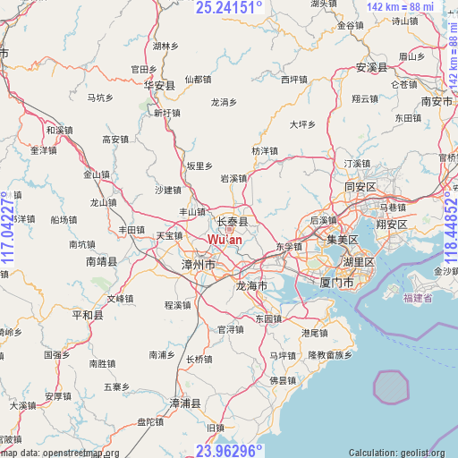
Wu’an GPS coordinates[2]
24° 36' 13.932" North, 117° 44' 43.404" East
| Map corner | latitude | longitude |
|---|---|---|
| Upper-left | 25.24151°, | 117.04227° |
| Center: | 24.60387°, | 117.74539° |
| Lower-right: | 23.96296°, | 118.44852° |
| Map W x H: | 142.2×142.2 km | = 88.4×88.4mi |
| max Lat: | 53.31946° ⇑88.1% North |
| Wu’an: | 24.60387° |
| min Lat: | ⇓11.9% South 18.22056° |
| min Long | Wu’an | max Long |
| 75.07348° | 117.74539° | 134.28917° |
| W 69.6%⇐ | ⇒30.4% E |
Elevation
Elevation of Wu’an is 7 m = 23 ft, and this is 477.8 m = 1568 ft below average elevation for this country.
| Max E: |
5622 m = 18445 ft | 94.3% |
| Avg. | 484.8 m = 1591 ft | |
| Wu’an | 7 m = 23 ft | |
Min E: |
-3 m = -10 ft | 5.7% |
See also: China elevation on elevation.city.
Geographical zone
Wu’an is located in North temperate zone (between Tropic of Cancer and the Arctic Circle). Distance of this Northern Tropic circle is 129.8 km =80.7 mi to South.| Distance of | km | miles | from Wu’an |
|---|---|---|---|
| North Pole | 7271.4 | 4518.2 | to North |
| Arctic Circle | 4665.5 | 2899 | to North |
| Tropic Cancer | 129.8 | 80.7 | to South |
| Equator | 2735.7 | 1699.9 | to South |


Nearby cities:
15 places around Wu’an: (largest is in red/bold)
• Datong
42.7 km =26.5 mi,  70°
70°
• Gangwei
41.5 km =25.8 mi,  140°
140°
• Guankou
24.9 km =15.5 mi,  87°
87°
• Houxi
29.3 km =18.2 mi,  84°
84°
• Nanpu
43.7 km =27.2 mi,  207°
207°
• Shancheng
42.3 km =26.3 mi,  252°
252°
• Shima
18.8 km =11.7 mi,  158°
158°
• Wuxian
44.8 km =27.8 mi, 69°
• Xiamen
36.7 km =22.8 mi,  112°
112°
• Xike
41.6 km =25.8 mi, 79°
• Xingbin
29.5 km =18.3 mi,  97°
97°
• Xinglin
29.8 km =18.5 mi, 98°
• Xinmin
40.8 km =25.4 mi, 72°
• Yingcun
36.3 km =22.6 mi, 90°
• Zhangzhou
13.6 km =8.5 mi,  222°
222°
Sources, notices
• [Note1] Compared only with cities in China existing in our database
• [Src1] Map data: © OpenStreetMap contributors (CC-BY-SA)
• [Src2] Other city data from geonames.org with taken over terms of usage.
• [Src3] Geographical zone / Annual Mean Temperature by Robert A. Rohde @ Wikipedia
