Nanpu geodata
Nanpu (Fujian) is a seat of a fourth-order administrative division; located in China in Asia/Shanghai (GMT+8) time zone. In our database, there are 1268 cities with bigger population. Compared to other cities in China, 89.4% of cities are located further ↑North; 68.9% of cities are located further ←West and 67.4% of cities have higher elevation than Nanpu. Note1


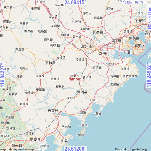
Nanpu GPS coordinates[2]
24° 15' 16.992" North, 117° 32' 47.004" East
| Map corner | latitude | longitude |
|---|---|---|
| Upper-left | 24.89415°, | 116.84327° |
| Center: | 24.25472°, | 117.54639° |
| Lower-right: | 23.61206°, | 118.24952° |
| Map W x H: | 142.6×142.6 km | = 88.6×88.6mi |
| max Lat: | 53.31946° ⇑89.4% North |
| Nanpu: | 24.25472° |
| min Lat: | ⇓10.6% South 18.22056° |
| min Long | Nanpu | max Long |
| 75.07348° | 117.54639° | 134.28917° |
| W 68.9%⇐ | ⇒31.1% E |
Elevation
Elevation of Nanpu is 63 m = 207 ft, and this is 421.8 m = 1384 ft below average elevation for this country.
| Max E: |
5622 m = 18445 ft | 67.4% |
| Avg. | 484.8 m = 1591 ft | |
| Nanpu | 63 m = 207 ft | |
Min E: |
-3 m = -10 ft | 32.6% |
See also: China elevation on elevation.city.
Geographical zone
Nanpu is located in North temperate zone (between Tropic of Cancer and the Arctic Circle). Distance of this Northern Tropic circle is 91 km =56.5 mi to South.| Distance of | km | miles | from Nanpu |
|---|---|---|---|
| North Pole | 7310.2 | 4542.3 | to North |
| Arctic Circle | 4704.3 | 2923.1 | to North |
| Tropic Cancer | 91 | 56.5 | to South |
| Equator | 2696.9 | 1675.8 | to South |


Nearby cities:
15 places around Nanpu: (largest is in red/bold)
• Aozhong
41 km =25.5 mi,  150°
150°
• Dongkeng
37.7 km =23.4 mi,  206°
206°
• Donglin
46.9 km =29.1 mi,  171°
171°
• Gangwei
47.2 km =29.3 mi,  81°
81°
• Lieyu
48.7 km =30.3 mi,  190°
190°
• Shancheng
33.3 km =20.7 mi,  322°
322°
• Shima
34.3 km =21.3 mi,  51°
51°
• Sui’an
19.7 km =12.2 mi,  161°
161°
• Wu’an
43.7 km =27.2 mi,  27°
27°
• Xiahe
38.4 km =23.9 mi,  226°
226°
• Xiaoxi
28.1 km =17.5 mi,  292°
292°
• Yunling
39.7 km =24.7 mi, 212°
• Zhaizipu
43.9 km =27.3 mi,  220°
220°
• Zhangzhou
30.8 km =19.1 mi,  21°
21°
• Zhengyang
34.9 km =21.7 mi, 170°
Sources, notices
• [Note1] Compared only with cities in China existing in our database
• [Src1] Map data: © OpenStreetMap contributors (CC-BY-SA)
• [Src2] Other city data from geonames.org with taken over terms of usage.
• [Src3] Geographical zone / Annual Mean Temperature by Robert A. Rohde @ Wikipedia
