Shima geodata
Shima (Fujian) is a seat of a third-order administrative division; located in China in Asia/Shanghai (GMT+8) time zone. With population of 68,375 people, there are 625 cities with bigger population in this country. Compared to other cities in China, 88.7% of cities are located further ↑North; 69.9% of cities are located further ←West and 88.7% of cities have higher elevation than Shima. Note1


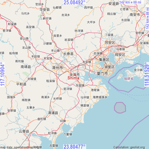
Shima GPS coordinates[2]
24° 26' 47.292" North, 117° 48' 43.776" East
| Map corner | latitude | longitude |
|---|---|---|
| Upper-left | 25.08492°, | 117.10904° |
| Center: | 24.44647°, | 117.81216° |
| Lower-right: | 23.80477°, | 118.51529° |
| Map W x H: | 142.3×142.3 km | = 88.4×88.4mi |
| max Lat: | 53.31946° ⇑88.7% North |
| Shima: | 24.44647° |
| min Lat: | ⇓11.3% South 18.22056° |
| min Long | Shima | max Long |
| 75.07348° | 117.81216° | 134.28917° |
| W 69.9%⇐ | ⇒30.1% E |
Elevation
Elevation of Shima is 11 m = 36 ft, and this is 473.8 m = 1554 ft below average elevation for this country.
| Max E: |
5622 m = 18445 ft | 88.7% |
| Avg. | 484.8 m = 1591 ft | |
| Shima | 11 m = 36 ft | |
Min E: |
-3 m = -10 ft | 11.3% |
See also: Shima elevation on elevation.city.
Geographical zone
Shima is located in North temperate zone (between Tropic of Cancer and the Arctic Circle). Distance of this Northern Tropic circle is 112.3 km =69.8 mi to South.| Distance of | km | miles | from Shima |
|---|---|---|---|
| North Pole | 7288.9 | 4529.1 | to North |
| Arctic Circle | 4683 | 2909.9 | to North |
| Tropic Cancer | 112.3 | 69.8 | to South |
| Equator | 2718.2 | 1689 | to South |


Nearby cities:
15 places around Shima: (largest is in red/bold)
• Gangwei
24.4 km =15.2 mi,  126°
126°
• Guankou
25.8 km =16 mi,  44°
44°
• Houxi
30.4 km =18.9 mi,  47°
47°
• Liuwudiancun
40.7 km =25.3 mi,  70°
70°
• Longjiao
32.6 km =20.3 mi, 130°
• Nanpu
34.3 km =21.3 mi,  231°
231°
• Wuyucun
35.9 km =22.3 mi,  110°
110°
• Wu’an
18.8 km =11.7 mi,  338°
338°
• Xiamen
27.5 km =17.1 mi,  82°
82°
• Xike
42.5 km =26.4 mi, 53°
• Xingbin
26.3 km =16.3 mi,  58°
58°
• Xinglin
26.4 km =16.4 mi, 59°
• Yingcun
34.2 km =21.3 mi, 59°
• Zhangzhou
17.5 km =10.9 mi,  295°
295°
• Zhenhaicun
35.2 km =21.9 mi, 126°
Sources, notices
• [Note1] Compared only with cities in China existing in our database
• [Src1] Map data: © OpenStreetMap contributors (CC-BY-SA)
• [Src2] Other city data from geonames.org with taken over terms of usage.
• [Src3] Geographical zone / Annual Mean Temperature by Robert A. Rohde @ Wikipedia
