Chagugang geodata
Chagugang (Tianjin) is a seat of a fourth-order administrative division; located in China in Asia/Shanghai (GMT+8) time zone. In our database, there are 1268 cities with bigger population. Compared to other cities in China, 83.9% of cities are located further ↓South; 65.7% of cities are located further ←West and 86.2% of cities have higher elevation than Chagugang. Note1


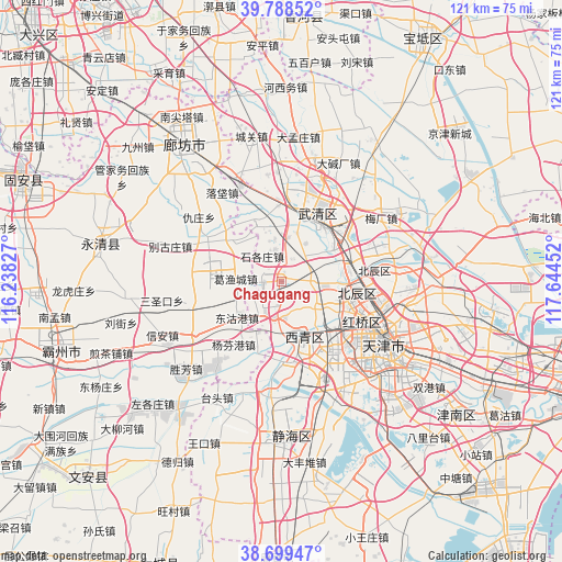
Chagugang GPS coordinates[2]
39° 14' 45.996" North, 116° 56' 29.004" East
| Map corner | latitude | longitude |
|---|---|---|
| Upper-left | 39.78852°, | 116.23827° |
| Center: | 39.24611°, | 116.94139° |
| Lower-right: | 38.69947°, | 117.64452° |
| Map W x H: | 121.1×121.1 km | = 75.2×75.2mi |
| max Lat: | 53.31946° ⇑16.1% North |
| Chagugang: | 39.24611° |
| min Lat: | ⇓83.9% South 18.22056° |
| min Long | Chagugang | max Long |
| 75.07348° | 116.94139° | 134.28917° |
| W 65.7%⇐ | ⇒34.3% E |
Elevation
Elevation of Chagugang is 14 m = 46 ft, and this is 470.8 m = 1545 ft below average elevation for this country.
| Max E: |
5622 m = 18445 ft | 86.2% |
| Avg. | 484.8 m = 1591 ft | |
| Chagugang | 14 m = 46 ft | |
Min E: |
-3 m = -10 ft | 13.8% |
See also: China elevation on elevation.city.
Geographical zone
Chagugang is located in North temperate zone (between Tropic of Cancer and the Arctic Circle). Distance of this Northern Tropic circle is 1757.8 km =1092.2 mi to South.| Distance of | km | miles | from Chagugang |
|---|---|---|---|
| North Pole | 5643.3 | 3506.6 | to North |
| Arctic Circle | 3037.4 | 1887.4 | to North |
| Tropic Cancer | 1757.8 | 1092.2 | to South |
| Equator | 4363.8 | 2711.5 | to South |


Nearby cities:
15 places around Chagugang: (largest is in red/bold)
• Beicang
15.6 km =9.7 mi,  94°
94°
• Chenzui
5.8 km =3.6 mi,  41°
41°
• Guoyuan Xincun
16.5 km =10.3 mi,  99°
99°
• Hangou
13.7 km =8.5 mi,  68°
68°
• Hanjiashu
13.1 km =8.1 mi,  119°
119°
• Huangzhuang
12.3 km =7.6 mi,  51°
51°
• Huangzhuang
14.5 km =9 mi, 42°
• Qingguang
9.5 km =5.9 mi, 123°
• Shigezhuang
7.1 km =4.4 mi,  322°
322°
• Shuangjie
13.5 km =8.4 mi,  83°
83°
• Shuangkou
7.3 km =4.5 mi, 96°
• Wangqingtuo
7.8 km =4.8 mi,  209°
209°
• Wangqinzhuang
12.9 km =8 mi, 98°
• Xinkou
16.3 km =10.1 mi,  168°
168°
• Yangliuqing
13.1 km =8.1 mi,  157°
157°
Sources, notices
• [Note1] Compared only with cities in China existing in our database
• [Src1] Map data: © OpenStreetMap contributors (CC-BY-SA)
• [Src2] Other city data from geonames.org with taken over terms of usage.
• [Src3] Geographical zone / Annual Mean Temperature by Robert A. Rohde @ Wikipedia
