Qingguang geodata
Qingguang (Tianjin) is a seat of a fourth-order administrative division; located in China in Asia/Shanghai (GMT+8) time zone. With population of 7,448 people, there are 834 cities with bigger population in this country. Compared to other cities in China, 83.7% of cities are located further ↓South; 66.2% of cities are located further ←West and 92.7% of cities have higher elevation than Qingguang. Note1


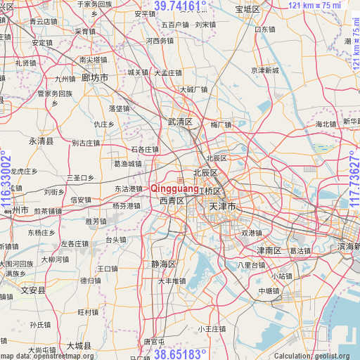
Qingguang GPS coordinates[2]
39° 11' 55.788" North, 117° 1' 59.304" East
| Map corner | latitude | longitude |
|---|---|---|
| Upper-left | 39.74161°, | 116.33002° |
| Center: | 39.19883°, | 117.03314° |
| Lower-right: | 38.65183°, | 117.73627° |
| Map W x H: | 121.2×121.2 km | = 75.3×75.3mi |
| max Lat: | 53.31946° ⇑16.3% North |
| Qingguang: | 39.19883° |
| min Lat: | ⇓83.7% South 18.22056° |
| min Long | Qingguang | max Long |
| 75.07348° | 117.03314° | 134.28917° |
| W 66.2%⇐ | ⇒33.8% E |
Elevation
Elevation of Qingguang is 8 m = 26 ft, and this is 476.8 m = 1564 ft below average elevation for this country.
| Max E: |
5622 m = 18445 ft | 92.7% |
| Avg. | 484.8 m = 1591 ft | |
| Qingguang | 8 m = 26 ft | |
Min E: |
-3 m = -10 ft | 7.3% |
See also: China elevation on elevation.city.
Geographical zone
Qingguang is located in North temperate zone (between Tropic of Cancer and the Arctic Circle). Distance of this Northern Tropic circle is 1752.6 km =1089 mi to South.| Distance of | km | miles | from Qingguang |
|---|---|---|---|
| North Pole | 5648.6 | 3509.9 | to North |
| Arctic Circle | 3042.7 | 1890.6 | to North |
| Tropic Cancer | 1752.6 | 1089 | to South |
| Equator | 4358.5 | 2708.2 | to South |


Nearby cities:
15 places around Qingguang: (largest is in red/bold)
• Beicang
8.7 km =5.4 mi,  61°
61°
• Chagugang
9.5 km =5.9 mi,  303°
303°
• Chenzui
10.4 km =6.5 mi,  336°
336°
• Dingzigu
11.1 km =6.9 mi,  104°
104°
• Guoyuan Xincun
8.7 km =5.4 mi,  72°
72°
• Hanjiashu
3.7 km =2.3 mi,  110°
110°
• Huayuandao
10.9 km =6.8 mi,  120°
120°
• Mazhuang
8.7 km =5.4 mi,  82°
82°
• Nancang
8.9 km =5.5 mi,  86°
86°
• Shuangjie
8.8 km =5.5 mi,  38°
38°
• Shuangkou
4.5 km =2.8 mi,  351°
351°
• Wangqinzhuang
5.9 km =3.7 mi, 55°
• Xiangyanglu
10.7 km =6.6 mi,  131°
131°
• Xianyang Beilu
9.4 km =5.8 mi, 100°
• Yangliuqing
7.4 km =4.6 mi,  202°
202°
Sources, notices
• [Note1] Compared only with cities in China existing in our database
• [Src1] Map data: © OpenStreetMap contributors (CC-BY-SA)
• [Src2] Other city data from geonames.org with taken over terms of usage.
• [Src3] Geographical zone / Annual Mean Temperature by Robert A. Rohde @ Wikipedia
