Chadian geodata
Chadian (Shaanxi) is a seat of a fourth-order administrative division; located in China in Asia/Shanghai (GMT+8) time zone. In our database, there are 1268 cities with bigger population. Compared to other cities in China, 67% of cities are located further ↓South; 85.2% of cities are located further →East and 82.6% of cities have lower elevation than Chadian. Note1


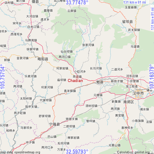
Chadian GPS coordinates[2]
33° 11' 17.988" North, 106° 27' 38.376" East
| Map corner | latitude | longitude |
|---|---|---|
| Upper-left | 33.77478°, | 105.75754° |
| Center: | 33.18833°, | 106.46066° |
| Lower-right: | 32.59793°, | 107.16379° |
| Map W x H: | 130.9×130.9 km | = 81.3×81.3mi |
| max Lat: | 53.31946° ⇑33% North |
| Chadian: | 33.18833° |
| min Lat: | ⇓67% South 18.22056° |
| min Long | Chadian | max Long |
| 75.07348° | 106.46066° | 134.28917° |
| W 14.8%⇐ | ⇒85.2% E |
Elevation
Elevation of Chadian is 822 m = 2697 ft, and this is 337.2 m = 1106 ft above average elevation for this country.
| Max E: |
5622 m = 18445 ft | 17.4% |
| Chadian | 822 m 2697 ft | |
| Avg. | 484.8 m = 1591 ft | |
Min E: |
-3 m = -10 ft | 82.6% |
See also: China elevation on elevation.city.
Geographical zone
Chadian is located in North temperate zone (between Tropic of Cancer and the Arctic Circle). Distance of this Northern Tropic circle is 1084.3 km =673.8 mi to South.| Distance of | km | miles | from Chadian |
|---|---|---|---|
| North Pole | 6316.9 | 3925.1 | to North |
| Arctic Circle | 3711 | 2305.9 | to North |
| Tropic Cancer | 1084.3 | 673.8 | to South |
| Equator | 3690.2 | 2293 | to South |


Nearby cities:
15 places around Chadian: (largest is in red/bold)
• Changgouhe
17.6 km =10.9 mi,  64°
64°
• Dingjunshan
19.3 km =12 mi,  106°
106°
• Guanyinsi
19.8 km =12.3 mi,  358°
358°
• Heiheba
3.2 km =2 mi,  331°
331°
• Hejiayan
14.8 km =9.2 mi,  302°
302°
• Lianghekou
20.7 km =12.9 mi, 330°
• Miaoba
13.2 km =8.2 mi,  260°
260°
• Nanping
20.4 km =12.7 mi,  198°
198°
• Qingyangyi
13.3 km =8.3 mi,  209°
209°
• Tuguanpu
10.5 km =6.5 mi,  127°
127°
• Wuhou
14.9 km =9.3 mi, 106°
• Xiakouyi
5.6 km =3.5 mi, 297°
• Xiaobianhe
5.6 km =3.5 mi,  28°
28°
• Xinpu
9.9 km =6.2 mi,  185°
185°
• Yudongzi
19.9 km =12.4 mi,  319°
319°
Sources, notices
• [Note1] Compared only with cities in China existing in our database
• [Src1] Map data: © OpenStreetMap contributors (CC-BY-SA)
• [Src2] Other city data from geonames.org with taken over terms of usage.
• [Src3] Geographical zone / Annual Mean Temperature by Robert A. Rohde @ Wikipedia
